Software Applications in Engineering Survey and Geomatics Analysis
VerifiedAdded on 2023/01/16
|10
|2496
|50
Report
AI Summary
This report provides an overview of survey software and geomatics in civil engineering. It discusses the purpose of survey software, its applications, and the equipment used, including the use of drag-and-drop interfaces, looping dynamics, and MEX for maintenance. The report also covers specifications, regulations, and standards, as well as data capture, presentation, processing, and management control. Furthermore, it explores geomatics, its benefits from computer-based technology, and its application in spatial data analysis. It highlights end-users, equipment, and data management aspects of geomatics software, including the use of GNSS systems and data processing tools. The report concludes by emphasizing the increasing impact of software engineering in both survey and geomatics, highlighting the need for continuous advancements and studies in these areas.
ENGINEERING SURVEY
By Name
Course
Instructor
Institution
Location
Date
By Name
Course
Instructor
Institution
Location
Date
Paraphrase This Document
Need a fresh take? Get an instant paraphrase of this document with our AI Paraphraser
Introduction
There has been an obvious great impact of software engineering as well as use of
computers on the improvement of technology1. The impacts of the computers in regards
to their capabilities of successful analysis can effectively contribute to the
interconnection within discrete fields.
Civil Engineering Survey Software
Purpose as related to the engineering profession
Survey software refers to an application platform which is used in the collection of
feedback that may be from a targeted sample by the use of a computer-assisted
method. The collection may be obtained by means of different ways. At the core,
computer software assists in the design, sending and analysis of the surveys usually by
the use of the internet. This goes along with the use of the drag and drop tools whose
functions are automated.
The survey software usually makes the entire process faster, easier and more accurate
to accomplish as opposed to the manual survey platforms. The use of survey software
can be in different ways including customer feedback, post event analysis, employee
satisfaction, research of the market and finally an assessment of the academic
programs2. In general, the software of the survey assists in the feedback analysis for
one to take the right action in regard to the problem at hand.
End users and personnel involved
Survey software is used by the surveyors who are already professionals in the field.
When the software is used, the professionals can calculate how well the process of the
1 Ahmed, F., Capretz, L.F., Bouktif, S., and Campbell, P., 2015. Soft skills and software development: A reflection from the software industry.
arXiv preprint arXiv:1507.06873.
2 Carvalho, M.M.D. and Rabechini Junior, R., 2015. Impact of risk management on project performance: the importance of soft
skills. International Journal of Production Research, 53(2), pp.321-340
surrey will fare on. In such cases, there is an analysis of veracious metrics including the
specific length of the questionnaire, the establishment of the relevance of the
questionnaire and finally evaluation of the history of the results of the survey. In case of
the existence of the more established solutions in the processes of survey, provision of
the knowledge base of the finest practices in the business will be enhanced.
Students aspiring to be surveyors and the survey professionals use the surveyor
software as a means of centralized data collection3. This kind of software makes the
collection of data more systematic through ensuring that all the feedback are kept in just
one database. This allows the surveyors to have processes that are in- real- time
immediately the answers are provided by the respondents.
Equipment used in the survey
The equipment that is used in the survey software will be dependent on the type of task
that is to be carried out. In the case of the survey builder, a drag-and-drop interface, as
well as relevant tools, will be used in the design and layout, preview, question morphing,
and versioning. This implies that the builder will create the front-end look as well as the
function of the survey although this must rely on the other features and conditions in
setting the behavior of the survey. The software tools like looping dynamics are used to
randomize or show the questions4. The maintenance of the survey software involves
inspections that are regularly done in order to detect and prevent any possible failure
before its occurrence and this can be achieved by the use of MEX.
Specifications, regulations, datum, standards among other characteristics
The use of the survey software usually comes into effect after certain standards have
been met. Good software for the survey must meet the flexibility standards which allow
one to effectively design though in different ways. The design may be based on the path
3 Dingsøyr, T., Røyrvik, E. and D array, H.K., 2019. Practical knowledge management tool uses in a software consulting company. arXiv
preprint arXiv:1903.01889
4 Doerflinger, J. and Dearden, A., 2013. Evolving a software development methodology for commercial ICTD projects. Information Technology
and International Development, 9(3), pp.43-60.
⊘ This is a preview!⊘
Do you want full access?
Subscribe today to unlock all pages.
Trusted by 1+ million students worldwide
where there will need to skip logic types, on the structure; allows rating, generation of
the multiple responses and finally, it should allow for the customization of the elements
through branding.
Although it is on a regulatory requirement that software of survey allows for scoring,
this should go beyond aggregating of Y/N responses5. Automation is datum in the
application of the survey software although there are advances that are made
depending on the level of operations required. The software should, therefore, allow for
the processes of multi-mode capabilities with appropriate tolerance that allows for the
routing as well as logic skip.
Data capture, presentations, processing and management control
The feature of the data analysis will always vary in terms of the complexities between
the low term premium plans and low costs. The standard analysis will basically show
the crucial summaries while the solutions of the complex problems will give solutions in
cross tabulation, weighting, and filtering. This implies that the software may possibly
handle multivariate statistical methods.
As a matter of perseveration conveniences, the survey software may allow for the
configuration of the interface that has the brand logo as well as other colors to give the
survey work an appealing and professional look6. This is usually made possible by the
use of the white bel. The management of the response is effectively done through the
setting of the data collection including the application of quota in the management of the
numbers, automatic categorization of the responses. This goes along with the tracking
of multiple iterations.
5 Gustavsson, T.K. and Hallin, A., 2014. Rethinking dichotomization: A critical perspective on the use of “hard” and “soft” in project
management research. International Journal of Project Management, 32(4), pp.568-577.
6 LaToza, T.D., Towne, W.B., Van Der Hoek, A. and Herbsleb, J.D., 2013, May. Crowd development. In 2013 6th International Workshop on
Cooperative and Human Aspects of Software Engineering (CHASE) (pp. 85-88). IEEE.
Paraphrase This Document
Need a fresh take? Get an instant paraphrase of this document with our AI Paraphraser
Civil Engineering geomatic software
Purpose as related to the engineering profession
Geomatics has been identified as one of the sciences which benefit intensively from the
computer-based technology. This is actually a new term that incorporates the processes
of digital mapping, microelectronic mechanical systems, spatial analysis of data,
surveying technologies combinations including photogrammetry,remote sensing,
geographic information system, global navigation satellite system among others7.
Geomatics can, therefore, be thought of as one of the interdisciplinary sciences which
have a combination of the term informatics and geodesy. Other than the professionals
that use this kind of the software in their routine activities, the undergraduate who is
studying geomatic engineering should be aware of the requirements and applications of
the same software so that they are capable of effectively interpreting problems that
emanate from the system of GNSS and software itself.
End users and personnel involved
The geomatic engineering professionals use this software in carrying out the analysis of
the statistics through estimation of the parameters within the activities of modeling as
well as referencing. The software is used to facilitate the computer-aided visualization,
use of the georeferencing as well as communication. The activities of planning,
management of land and other questions that are related to space and environment are
effectively handled by the use of the geomatic software. As mentioned before,most of
the activities that are handled by the use of the software are easy to monitor.
This particular software is this introduced to the undergraduates that are pursuing
geomatic engineering in the development of the competence efficiently. The skills that
are acquired are considered relevant and useful in the evaluation of instrumentation
errors, transferring and presentation of the GIS data, map positioning among others.
7 Lavy, I. and Yadin, A., 2013. A soft skills-An important key for employability in the" shift to a service-driven economy" era. International
Journal of e-Education, e-Business, e-Management and e-Learning, 3(5), p.416.
Equipment used in the geomatics software
This kind of software employs the use of the equipment like sensors, receivers, and
other devices that are used in the measurements of the catastrophic within the context
of geomatic engineering. In the cases of the GNSS systems, the software will
coordinate the above requirements in order to control the practical application through
obtaining the analysis from the satellites. This is usually done with advanced precision.
The software is basically made of other crucial parts including a tool for the data
processing, tool for the data analysis and finally the graphic user interface.
Specifications, regulations, datum, standards among other characteristics
Although the graphic user interfaces of the majority of the computers and software are
utilizing programming technologies, the pioneers of the engineering software especially
geomatic have set down the data channels which are used in the communication as per
the standards. The necessity to the software development competencies is normally
observed from the measurement devices of positioning as translated in the plans and
maps8. These activities are used as the reference points of its suitability or datum. The
design optimization becomes one of the crucial specifications requirement of this kind of
software
Data capture, presentations, processing and management control
The capturing of data by this kind of software relies on the receivers that are
synchronized with the satellites. This reveals crucial information with regard to planning
and mapping. The information received is normally undertaken through processing
which may include topographical analysis. The presentations of the data are given in
the form of the images and sometimes in the form of the tables. This data, however, is
managed through the use of a database that is subject to periodic updates9. The
management of the data includes accessing the prior information and doing a
comparison with the recently detailed information so as to avoid duplication.
8 Marlow, J. and Dabbish, L., 2013, February. Activity traces and signals in software developer recruitment and hiring. In Proceedings of the
2013 conference on Computer supported cooperative work (pp. 145-156). ACM.
9 Radermacher, A., Walia, G. and Knudson, D., 2014, May. Investigating the skill gap between graduating students and industry expectations.
In Companion Proceedings of the 36th international conference on software engineering (pp. 291-300). ACM
⊘ This is a preview!⊘
Do you want full access?
Subscribe today to unlock all pages.
Trusted by 1+ million students worldwide

Conclusion
In the recent industrial setups.at least every branch of engineering has been affected by
the use of the software. Although this particular paper has only emphasized the use of
geomatics software as well as the survey software, the same can be done for other
engineering fields. It has effectively been illustrated in this particular pare that the
impacts of software engineering in survey and geomatic would increase on a daily
basis10. It has, therefore, become very important to have studies conducted towards the
perfection of their utility.
References
Ahmed, F., Capretz, L.F., Bouktif, S., and Campbell, P., 2015. Soft skills and software
development: A reflection from the software industry. arXiv preprint arXiv:1507.06873.
Carvalho, M.M.D. and Rabechini Junior, R., 2015. Impact of risk management on
project performance: the importance of soft skills. International Journal of Production
Research, 53(2), pp.321-340.
10 Sedelmaier, Y. and Landes, D., 2014, April. Software engineering body of skills (WEBOS). In 2014 IEEE Global Engineering Education
Conference (EDUCON) (pp. 395-401). IEEE.
Paraphrase This Document
Need a fresh take? Get an instant paraphrase of this document with our AI Paraphraser
Dingsøyr, T., Røyrvik, E. and D array, H.K., 2019. Practical knowledge management
tool uses in a software consulting company. arXiv preprint arXiv:1903.01889.
Doerflinger, J. and Dearden, A., 2013. Evolving a software development methodology
for commercial ICTD projects. Information Technology and International
Development, 9(3), pp.43-60.
Gustavsson, T.K. and Hallin, A., 2014. Rethinking dichotomization: A critical perspective
on the use of “hard” and “soft” in project management research. International Journal of
Project Management, 32(4), pp.568-577.
LaToza, T.D., Towne, W.B., Van Der Hoek, A. and Herbsleb, J.D., 2013, May. Crowd
development. In 2013 6th International Workshop on Cooperative and Human Aspects
of Software Engineering (CHASE) (pp. 85-88). IEEE.
Lavy, I. and Yadin, A., 2013. A soft skills-An important key for employability in the" shift
to a service-driven economy" era. International Journal of e-Education, e-Business, e-
Management and e-Learning, 3(5), p.416.
Marlow, J. and Dabbish, L., 2013, February. Activity traces and signals in software
developer recruitment and hiring. In Proceedings of the 2013 conference on Computer
supported cooperative work (pp. 145-156). ACM.
Radermacher, A., Walia, G. and Knudson, D., 2014, May. Investigating the skill gap
between graduating students and industry expectations. In Companion Proceedings of
the 36th international conference on software engineering (pp. 291-300). ACM.
Sedelmaier, Y. and Landes, D., 2014, April. Software engineering body of skills
(WEBOS). In 2014 IEEE Global Engineering Education Conference (EDUCON) (pp.
395-401). IEEE.
Appendix
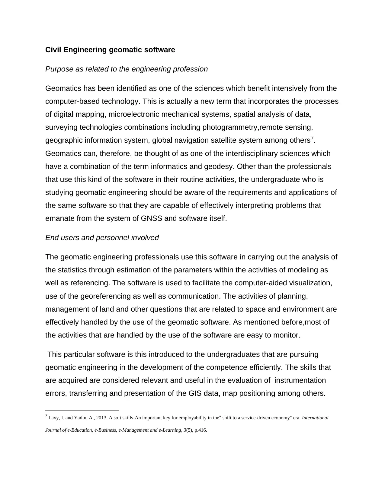
Figure 1: Sample question of survey question on the interface.
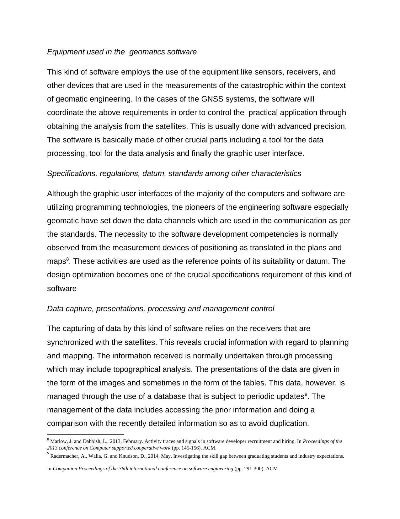
Figure 2: Sample of online survey software.
Figure 2: Sample of online survey software.
⊘ This is a preview!⊘
Do you want full access?
Subscribe today to unlock all pages.
Trusted by 1+ million students worldwide

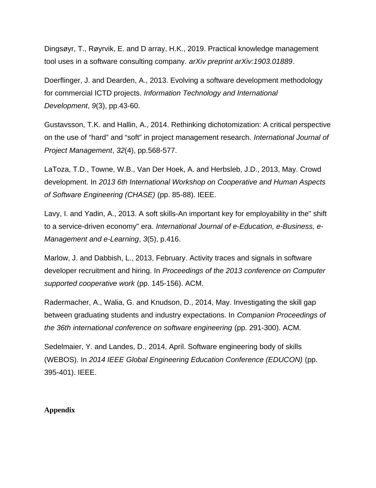
Figure 3: Sample results of geomatic software use.
1 out of 10
Related Documents


Your All-in-One AI-Powered Toolkit for Academic Success.
+13062052269
info@desklib.com
Available 24*7 on WhatsApp / Email
![[object Object]](/_next/static/media/star-bottom.7253800d.svg)
Unlock your academic potential
Copyright © 2020–2026 A2Z Services. All Rights Reserved. Developed and managed by ZUCOL.