Sustainability and Climate Adaptation Plan for the City of Sydney
VerifiedAdded on 2023/03/31
|15
|2446
|434
Report
AI Summary
This report provides a comprehensive analysis of the sustainability of the City of Sydney area, focusing on its current status and outlining a plan for its future. The analysis covers various aspects, including the area's history, transport facilities, urban form, water use and management, nature integration, and potential climate change impacts. The report identifies key sustainability issues such as high average temperatures, lack of biodiversity, carbon emissions, and waste management. The proposed plan for the future of the City of Sydney area includes climate adaptation measures through increased tree cover and building design policies, increased biodiversity by expanding parklands, reduction of carbon emissions by shifting to renewable energy sources and promoting eco-friendly transport, and improved water management through separated treatment plants and recycled water use, and waste management strategies. The goal is to create a more climate-resilient, water-conscious, and environmentally friendly urban area.
Sus523
Paraphrase This Document
Need a fresh take? Get an instant paraphrase of this document with our AI Paraphraser
Sus523
Contents
LIST OF TABLES......................................................................................................................................3
LIST OF FIGURES.....................................................................................................................................3
INTRODUCTION.......................................................................................................................................4
RATIONALE FOR SELECTION OF PROJECT AREA............................................................................5
ANALYSIS OF CURRENT STATUS........................................................................................................6
HISTORY OF AREA..............................................................................................................................6
TRANSPORT FACILITIES....................................................................................................................6
CURRENT URBAN FORM...................................................................................................................7
WATER USE AND MANAGEMENT...................................................................................................7
NATURE INTEGRATION AND BIODIVERSITY...............................................................................8
POSSIBLE IMPACTS OF CLIMATE CHANGE...................................................................................8
URBAN SUSTAINABILITY..................................................................................................................8
VISION FOR THE FUTURE OF THE CITY OF SYDNEY AREA..........................................................9
PLAN FOR THE FUTURE OF THE CITY OF SYDNEY AREA.............................................................9
CLIMATE ADAPTATION.....................................................................................................................9
INCREASED BIODIVERSITY............................................................................................................11
REDUCTION OF CARBON EMISSIONS...........................................................................................11
WATER MANAGEMENT...................................................................................................................12
WASTE MANAGEMENT....................................................................................................................13
REFERENCES..........................................................................................................................................14
2
Sus523
LIST OF TABLES
Table 1: Main Modes of Transport 2................................................................................................7
LIST OF FIGURES
Figure 1: Map for the City of Sydney Area.....................................................................................4
Figure 2: Visualization of Climate Adaptation through Increased Plant and Tree Cover ............10
3
⊘ This is a preview!⊘
Do you want full access?
Subscribe today to unlock all pages.
Trusted by 1+ million students worldwide
Sus523
INTRODUCTION
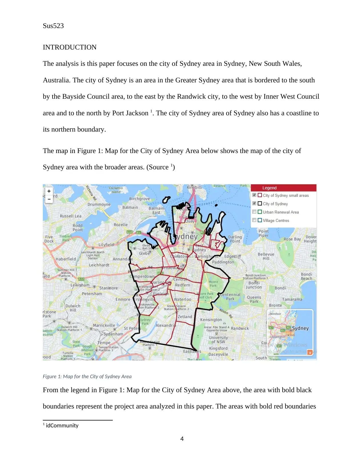
The analysis is this paper focuses on the city of Sydney area in Sydney, New South Wales,
Australia. The city of Sydney is an area in the Greater Sydney area that is bordered to the south
by the Bayside Council area, to the east by the Randwick city, to the west by Inner West Council
area and to the north by Port Jackson 1. The city of Sydney area of Sydney also has a coastline to
its northern boundary.
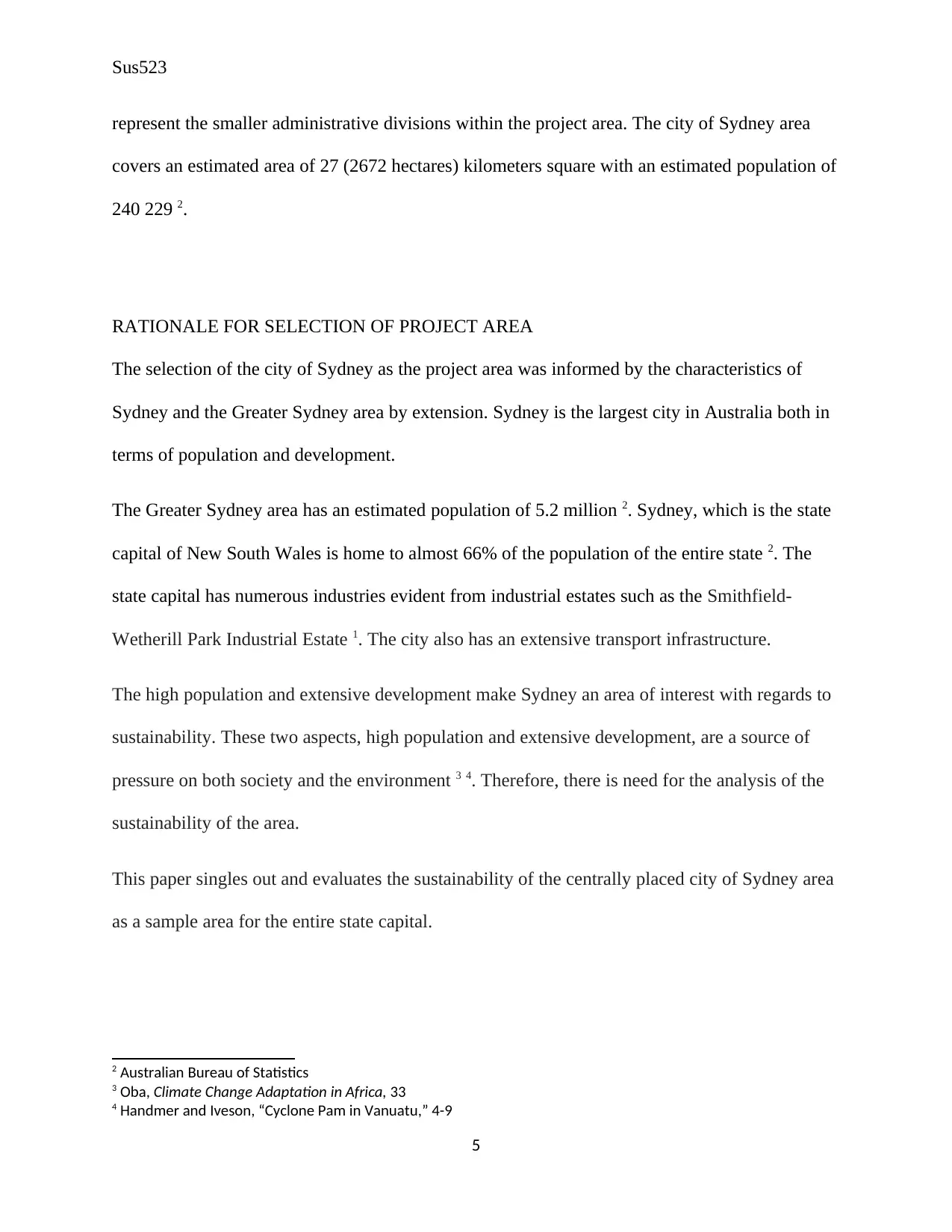
The map in Figure 1: Map for the City of Sydney Area below shows the map of the city of
Sydney area with the broader areas. (Source 1)
Figure 1: Map for the City of Sydney Area
From the legend in Figure 1: Map for the City of Sydney Area above, the area with bold black
boundaries represent the project area analyzed in this paper. The areas with bold red boundaries
1 idCommunity
4
INTRODUCTION
The analysis is this paper focuses on the city of Sydney area in Sydney, New South Wales,
Australia. The city of Sydney is an area in the Greater Sydney area that is bordered to the south
by the Bayside Council area, to the east by the Randwick city, to the west by Inner West Council
area and to the north by Port Jackson 1. The city of Sydney area of Sydney also has a coastline to
its northern boundary.
The map in Figure 1: Map for the City of Sydney Area below shows the map of the city of
Sydney area with the broader areas. (Source 1)
Figure 1: Map for the City of Sydney Area
From the legend in Figure 1: Map for the City of Sydney Area above, the area with bold black
boundaries represent the project area analyzed in this paper. The areas with bold red boundaries
1 idCommunity
4
Paraphrase This Document
Need a fresh take? Get an instant paraphrase of this document with our AI Paraphraser
Sus523
represent the smaller administrative divisions within the project area. The city of Sydney area
covers an estimated area of 27 (2672 hectares) kilometers square with an estimated population of
240 229 2.
RATIONALE FOR SELECTION OF PROJECT AREA
The selection of the city of Sydney as the project area was informed by the characteristics of
Sydney and the Greater Sydney area by extension. Sydney is the largest city in Australia both in
terms of population and development.
The Greater Sydney area has an estimated population of 5.2 million 2. Sydney, which is the state
capital of New South Wales is home to almost 66% of the population of the entire state 2. The
state capital has numerous industries evident from industrial estates such as the Smithfield-
Wetherill Park Industrial Estate 1. The city also has an extensive transport infrastructure.
The high population and extensive development make Sydney an area of interest with regards to
sustainability. These two aspects, high population and extensive development, are a source of
pressure on both society and the environment 3 4. Therefore, there is need for the analysis of the
sustainability of the area.
This paper singles out and evaluates the sustainability of the centrally placed city of Sydney area
as a sample area for the entire state capital.
2 Australian Bureau of Statistics
3 Oba, Climate Change Adaptation in Africa, 33
4 Handmer and Iveson, “Cyclone Pam in Vanuatu,” 4-9
5
Sus523
ANALYSIS OF CURRENT STATUS
HISTORY OF AREA
The city of Sydney was officially established in 1842 alongside Sydney itself 1. Massive
infrastructural development started in the 1850s with the extension of the railway and waterways
in the city of Sydney area. The massive infrastructural development plan involved the
construction of a railway system within Sydney and extending it to Melbourne 5. It also included
the extension of the road and waterways systems in the 1990s that are currently present in the
area 1.
TRANSPORT FACILITIES
The area has several rail networks with most notable railway stations being the Museum Station
platform 1 and the St. James Station platform 2 in the Sydney CBD area of the city of Sydney.
The waterway channel to the north of the area provides for water transport using ferries from
Darling Harbor to Garden Island Wharf. Major road networks include the Cahill Expressway,
Bradfield Highway, Western distributor, Eastern distributor and Parramatta Road 1.
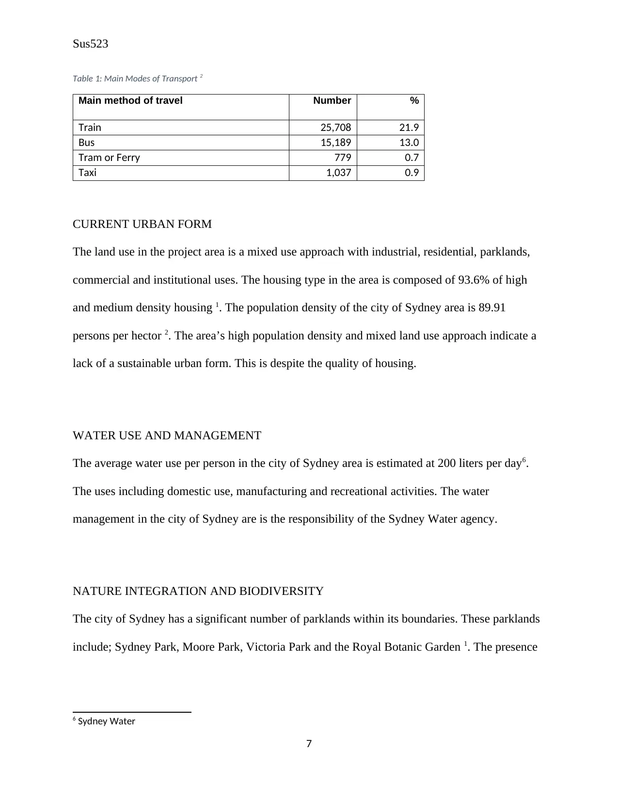
The summary of the modes of transport in the city of Sydney area is given in Table 1: Main
Modes of Transport below. The rail transport is fairly cheap and reasonably fast mode of
transport and therefore provides convenience transportation for the residents in the area. This
mode is however limited in its consumption of energy; this is especially with the slow
conversion from rail to light rail transportation.
5 AECOM Australia Pty Ltd, “Environmental Impact Statement”, 51-59
6
ANALYSIS OF CURRENT STATUS
HISTORY OF AREA
The city of Sydney was officially established in 1842 alongside Sydney itself 1. Massive
infrastructural development started in the 1850s with the extension of the railway and waterways
in the city of Sydney area. The massive infrastructural development plan involved the
construction of a railway system within Sydney and extending it to Melbourne 5. It also included
the extension of the road and waterways systems in the 1990s that are currently present in the
area 1.
TRANSPORT FACILITIES
The area has several rail networks with most notable railway stations being the Museum Station
platform 1 and the St. James Station platform 2 in the Sydney CBD area of the city of Sydney.
The waterway channel to the north of the area provides for water transport using ferries from
Darling Harbor to Garden Island Wharf. Major road networks include the Cahill Expressway,
Bradfield Highway, Western distributor, Eastern distributor and Parramatta Road 1.
The summary of the modes of transport in the city of Sydney area is given in Table 1: Main
Modes of Transport below. The rail transport is fairly cheap and reasonably fast mode of
transport and therefore provides convenience transportation for the residents in the area. This
mode is however limited in its consumption of energy; this is especially with the slow
conversion from rail to light rail transportation.
5 AECOM Australia Pty Ltd, “Environmental Impact Statement”, 51-59
6
⊘ This is a preview!⊘
Do you want full access?
Subscribe today to unlock all pages.
Trusted by 1+ million students worldwide
Sus523
Table 1: Main Modes of Transport 2
Main method of travel Number %
Train 25,708 21.9
Bus 15,189 13.0
Tram or Ferry 779 0.7
Taxi 1,037 0.9
CURRENT URBAN FORM
The land use in the project area is a mixed use approach with industrial, residential, parklands,
commercial and institutional uses. The housing type in the area is composed of 93.6% of high
and medium density housing 1. The population density of the city of Sydney area is 89.91
persons per hector 2. The area’s high population density and mixed land use approach indicate a
lack of a sustainable urban form. This is despite the quality of housing.
WATER USE AND MANAGEMENT
The average water use per person in the city of Sydney area is estimated at 200 liters per day6.
The uses including domestic use, manufacturing and recreational activities. The water
management in the city of Sydney are is the responsibility of the Sydney Water agency.
NATURE INTEGRATION AND BIODIVERSITY
The city of Sydney has a significant number of parklands within its boundaries. These parklands
include; Sydney Park, Moore Park, Victoria Park and the Royal Botanic Garden 1. The presence
6 Sydney Water
7
Paraphrase This Document
Need a fresh take? Get an instant paraphrase of this document with our AI Paraphraser
Sus523
of parklands represents an aspect of nature integration in an area 7 8. However, since these parks
are not necessarily game reserves, then the area cannot be considered as biodiverse.
POSSIBLE IMPACTS OF CLIMATE CHANGE
Climate change has resulted in increase in the global average temperature over the years 9. The
city of Sydney area has been exposed to this increase in average temperature with recorded
temperatures as high as 47 degrees Celsius in 2018 10. The area has also been exposed to both
drought and warming of the ocean, as a result of climate change. The ocean life to the north of
the area has been affected by the increase in ocean temperatures in addition to water pollution
and carbon emissions.
URBAN SUSTAINABILITY
The city of Sydney area is faced with sustainability issues such as the high average temperatures,
lack of biodiversity, carbon emissions, waste management and water management. These issues
present opportunities for the development of sustainability measures for the city of Sydney area.
VISION FOR THE FUTURE OF THE CITY OF SYDNEY AREA
The vision for the future of the city of Sydney area involve having an area that is well adapted to
the climate especially in terms of the increasing average temperatures. The city of Sydney area
will in future be a water-conscious urban area. Key competencies for this will be water
7 Sustainable Tourism in Galapagos
8 Carrington, Environment
9 Jacobson, “Review of Solutions to Global Warming, Air Pollution, and Energy Security,” 148-173
10 Australian Government
8
Sus523
management efficiency and maximized water collection. The future city of Sydney area will
have reduced pollution both with regards to proper waste management and reduced carbon
emissions. In future, the city of Sydney area will also have more biodiversity in addition to the
integration of nature.
PLAN FOR THE FUTURE OF THE CITY OF SYDNEY AREA
CLIMATE ADAPTATION
Climate adaptation can be defined as the process of setting measures that will enable a region to
offset the impacts and effects of global warming 11 12. In the city of Sydney area, interest with
regards to climate adaptability is the rise in the average temperatures in the area. A number of
adaptation measures are available for offsetting the rise in the average temperatures, however,
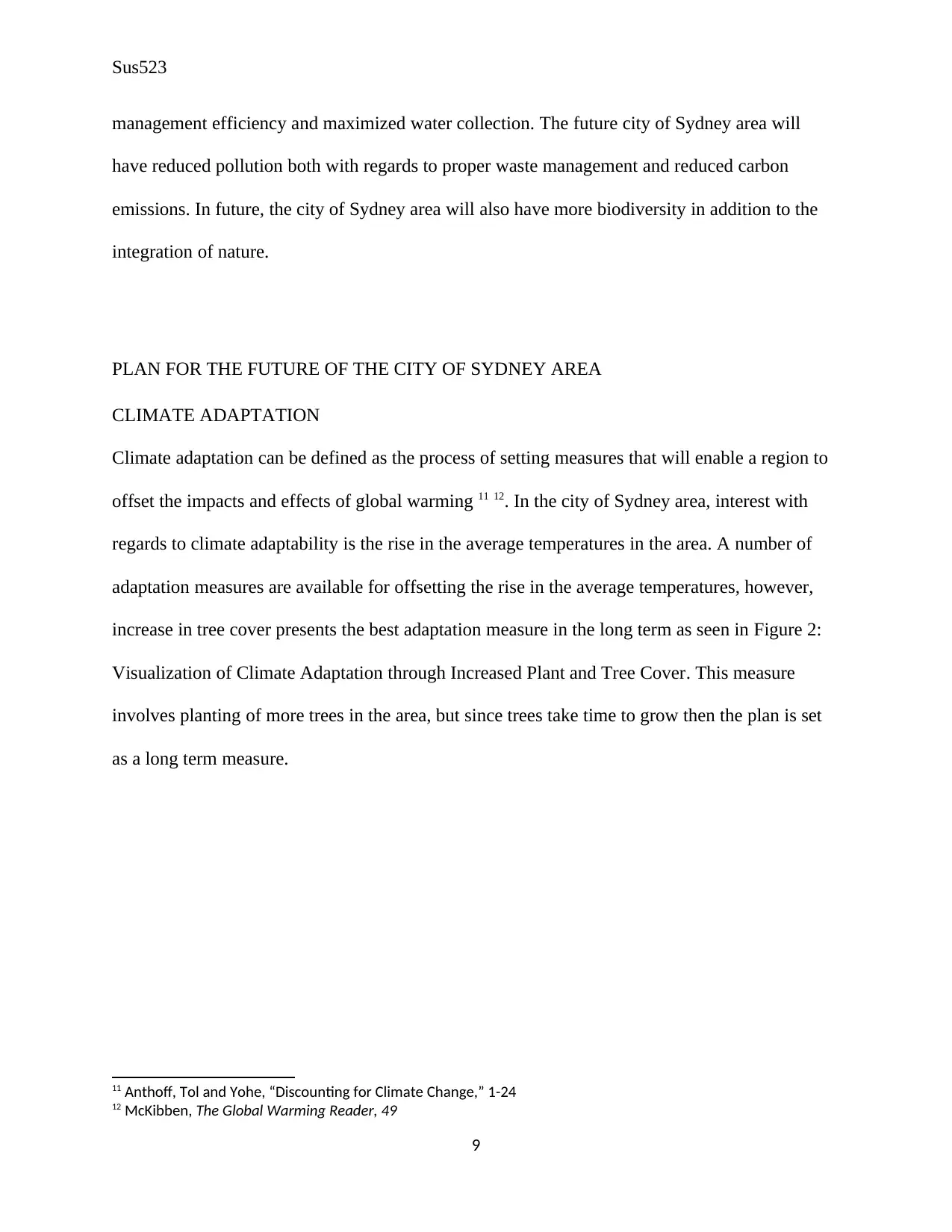
increase in tree cover presents the best adaptation measure in the long term as seen in Figure 2:
Visualization of Climate Adaptation through Increased Plant and Tree Cover. This measure
involves planting of more trees in the area, but since trees take time to grow then the plan is set
as a long term measure.
11 Anthoff, Tol and Yohe, “Discounting for Climate Change,” 1-24
12 McKibben, The Global Warming Reader, 49
9
management efficiency and maximized water collection. The future city of Sydney area will
have reduced pollution both with regards to proper waste management and reduced carbon
emissions. In future, the city of Sydney area will also have more biodiversity in addition to the
integration of nature.
PLAN FOR THE FUTURE OF THE CITY OF SYDNEY AREA
CLIMATE ADAPTATION
Climate adaptation can be defined as the process of setting measures that will enable a region to
offset the impacts and effects of global warming 11 12. In the city of Sydney area, interest with
regards to climate adaptability is the rise in the average temperatures in the area. A number of
adaptation measures are available for offsetting the rise in the average temperatures, however,
increase in tree cover presents the best adaptation measure in the long term as seen in Figure 2:
Visualization of Climate Adaptation through Increased Plant and Tree Cover. This measure
involves planting of more trees in the area, but since trees take time to grow then the plan is set
as a long term measure.
11 Anthoff, Tol and Yohe, “Discounting for Climate Change,” 1-24
12 McKibben, The Global Warming Reader, 49
9
⊘ This is a preview!⊘
Do you want full access?
Subscribe today to unlock all pages.
Trusted by 1+ million students worldwide
Sus523
Figure 2: Visualization of Climate Adaptation through Increased Plant and Tree Cover 13
(Source 13)
The short term measure will be the introducing policy on the designing of building to cater for
the rise in average temperatures. Through this policy, future building designs will be required to
include open spaces that will allow for temperature reduction within the buildings. The policy
will also make it necessary for current building owners to explore measures for making them
more adapted for the increased temperatures in the area. The low cost of planting trees for the
long term climate adaptation for the area means that the long term plan will not be subject to
financial constraints. The short term measure will however require legislative approval from the
relevant administrative councils.
13 VCCCAR
10
Paraphrase This Document
Need a fresh take? Get an instant paraphrase of this document with our AI Paraphraser
Sus523
INCREASED BIODIVERSITY
The city of Sydney area has a number of parklands such as the Sydney Park, Moore Park,
Victoria Park and the Royal Botanic Garden 1. These parklands cover a significant area in the
project area. However, there is need to increase the area covered by the parklands as a means of
increasing open spaces for better climate adaptability and for providing for recreational spaces.
These parklands also need to have more diverse plant and animal life. So as to achieve this,
unoccupied areas immediately bordering the existing parklands will be absorbed into the existing
parklands.
REDUCTION OF CARBON EMISSIONS
In order to reduce the carbon emissions in the city of Sydney area, the area has to reduce its
reliance on coal-fired stations for energy requirements. Coal-fired stations account for up to 90%
of the power consumed in the city of Sydney area 2. There will be need for a shift from coal-fired
stations to renewable energy sources for power production. Encouraging the residents to
purchase and install solar panels for powering their houses will be first step towards the shift in
energy use. The city of Sydney area will also install solar plants, geothermal plants and wind
farms to harness the available solar, geothermal and wind energy in the area. These three sources
will substitute the coal-fired stations in the area. Solar, geothermal and wind energy represent
sustainable and renewable energy alternatives to the traditional fossil fuels 14.
The reduction of carbon emission will also involve a change in the approach in transport. Road
vehicles in the area will be limited to eco-friendly models such as electric cars and cars that use
14 Sustainable Development Goals
11
Sus523
less pollutant fuels such as mixtures of ethanol and normal vehicle fuels. This will reduce the
amount of carbon emissions from road vehicles.
WATER MANAGEMENT
Shifting water management will require understanding of water requirements and water
treatment and sources in the area. Only 2% of water provided for the city of Sydney are is used
for drinking, this is despite 100% of the provided water being treated to the quality of drinking
water 3. Therefore, the treatment plants and water delivery channels (water pipes infrastructure)
for drinking water and other uses should be separated.
The water in the treatment plants and delivery channels for drinking water should be treated to
the quality of drinking water. The water in the treatment plants and delivery channels for other
uses should be treated to acceptable qualities. This will be important in improving the efficiency
of water management in the area.
The shift in water treatment and delivery channels will also enable the introduction of recycled
water into the water system in the area. The recycled water will be introduced into the delivery
channels for non-drinking water.
The water management plan will as well involve the construction of water pans and dams. Water
pans and dams will be essential in the harvesting and storage of storm water for both drinking
and non-drinking use. This water management plan will help in reducing the storm water loss in
the area.
12
⊘ This is a preview!⊘
Do you want full access?
Subscribe today to unlock all pages.
Trusted by 1+ million students worldwide
1 out of 15
Related Documents


Your All-in-One AI-Powered Toolkit for Academic Success.
+13062052269
info@desklib.com
Available 24*7 on WhatsApp / Email
![[object Object]](/_next/static/media/star-bottom.7253800d.svg)
Unlock your academic potential
Copyright © 2020–2026 A2Z Services. All Rights Reserved. Developed and managed by ZUCOL.