Sydney's Urban Landscape: Circular Quay, The Rocks, Darling Harbour

Verified

Added on  2021/06/17

|7
|908
|148
Report
AI Summary
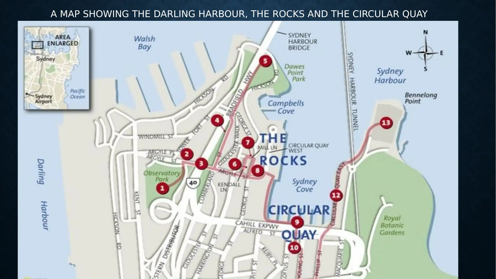
This report provides an overview of three key locations in Sydney: Circular Quay, The Rocks, and Darling Harbour. It describes each area's geographical location, notable features, and accessibility, including transport options such as ferries, buses, and railways. The report highlights the historical significance of The Rocks, the tourist appeal of Circular Quay, and the recreational aspects of Darling Harbour. It emphasizes access points like the Sydney Harbour Bridge and the public transport systems. The report concludes with a map showing the locations and cites several references supporting the information presented.
Document Page
QUESTION 3(A)
tabler-icon-diamond-filled.svg

Paraphrase This Document

Need a fresh take? Get an instant paraphrase of this document with our AI Paraphraser
Document Page
CIRCULAR QUAY SYDNEY
Circular Quay is a harbor that is part of Sydney city and is located between Bennelong Point and The
Rocks in the northern parts of Sydney district. It is situated at the center of Sydney cove which involves
the main settlement area of Australia."The Quay" is the city's main ferry terminus and a popular tourist
destination and acts as a key gateway that connects the locals and different worldwide visitors to the
attraction sites, for example, Sydney Harbor and Opera house. It has several historical sites, for example,
the Cadman's cottage which is geographically situated at George street. This particularly
Accessibility
The Circular Quay has vast transport systems with a large ferry, bus interchange, and railway. This buzz
place is composed of vibrant ferries that significantly leaves at regular time intervals moving people to
different parts, for example, Watsons Bay. It's also an important interlink channel for siders moving to work
acting as a gateway for many local individuals accessing the Manley's surf beach.
Notable features allowing easy access to the area include:
There is an Overseas Passenger Terminal, there exist a large part of Sydney transport and communication
services that are aimed to ensure cruise ships operate in an efficient way.
The place boasts of a major advanced underground railway system which loops around the central
business district and is referred to as the City circle. It has great views which makes it convenient for
people to access it as they are also assured of great food and accommodation facilities in different hotels.
Document Page
THE ROCKS SYDNEY

The Rocks is usually an urban locality, tourist destination and historic area of Sydney's city. It is located in the state of New
South Wales, to the immediate north-west side of the Sydney central business district and on the southern shore of
Sydney Harbor. It is composed of laneways and differently constructed sandstones The Rock Sydney is known for its vast
historical background with museums and contemporary art exhibitions displaying works of art from all over.
Accessibility
The Rocks has historic laneways and paths, the Sydney Harbor Bridge being the major landmark in the area allows easy
access to the area. The bridge contains a harbor front walk from Circular Quay to the international passenger terminal, one
can cycle over the bridge, climb up the Bridge Pylon and climb to the top of the arch of the bridge for a spectacular view of
the harbor. The laneways and paths allow exploration by foot which is the best way of touring the accessible open-air rock
markets where locals and tourist mingle, purchasing street food and handmade fashions, access pubs and many of the
upscale restaurants. The Rocks bring in both the locals and other visitors across the globe in order to access and experience
features such as the Campbell's Cove as they enjoy various sorts of food in pubs like Lord Nelson and the Australian Pub
commonly known for its food specialty.
Document Page
DA RLI N G H A RB O U R S YDN EY
Darling Harbor which was originally known as Long Cove is a harbor adjacent to the city center of Sydney. The harbor
stretches and unmasks its scale structure on New wales at the core of Australia's largest city Apart from being a harbor
it is generally a massive recreational Centre that is usually located the on western outskirts of the Sydney city central
business district.
Accessibility
Typically, Darling Harbor is always accessible through the use of different modes of public transport. It is served by the
Dullish Hill Line. There exist various ways to experience and access the harbor. an individual can walk continuously
over the harbor bridge on the walkway path where one locates the Fort St entrance on the eastern side of Observatory
Hill. Alternatively, one can also access through the Circular Quay which moves into the overseas terminal commonly
known as the harbor front walk. Also, one can also walk and climb directly up the Pylon bridge located on the
southeastern side. In order to access the harbor, one can cycle a bike through the cyclist lane located on the western
side near Milsons point. Key points that allow easy access is the Pyrmont Bay stations that have several Ferries
transporting people, vehicles, instruments, and goods across the harbor.
tabler-icon-diamond-filled.svg

Paraphrase This Document

Need a fresh take? Get an instant paraphrase of this document with our AI Paraphraser
Document Page
A MAP SHOWING THE DARLING HARBOUR, THE ROCKS AND THE CIRCULAR QUAY
Document Page
REFERENCES
Cheng & Von Behren,. U.S. Patent No. 8,396,888. 3rd edition (Washington, DC: U.S. Patent and Trademark
Office,2013,pp26).
Coutts et al. "Using geographical information system to model the effects of green space accessibility on
mortality.3rd edition (Florida." Geocarto International 25, 2010: 471-484).
Manaugh et al . "The effect of neighbourhood characteristics, accessibility, home–work location, and
demographics on commuting distances.2nd edition (Newyork Oxford 2010 627-646).
Klein, Elliot. "Geographical location authentication method."3rd edition (Washington DC, U.S. Patent 8,090,351,
issued January 3, 2012).
Document Page
END
chevron_up_icon
1 out of 7
circle_padding
hide_on_mobile
zoom_out_icon
[object Object]