Engineering Surveying: Total Station Use in Water Reservoir Project
VerifiedAdded on 2023/06/12
|10
|2364
|498
Report
AI Summary
This report provides an overview of engineering surveying, focusing on the application of a total station in monitoring Southern California’s water reservoir. It discusses the equipment used, including its operation, calibration, and maintenance, along with the personnel involved and end-users. The report details the specifications, tolerances, datum, and relevant legislation and regulations governing the use of total stations. Furthermore, it explains data management processes, including data capture, processing, presentation, and quality control. The report highlights the importance of total stations in ensuring the stability and accurate monitoring of water levels in critical infrastructure projects. Desklib offers students access to similar solved assignments and study resources to enhance their understanding of engineering surveying principles and practices.

Engineering Surveying 1
ENGINEERING SURVEYING
Name
Course
Professor
University
City/state
Date
ENGINEERING SURVEYING
Name
Course
Professor
University
City/state
Date
Paraphrase This Document
Need a fresh take? Get an instant paraphrase of this document with our AI Paraphraser
Engineering Surveying 2
Engineering Surveying
INTRODUCTION
Engineering surveying is one type of survey that is very crucial in any construction
project as it helps in collecting data about the exact positions of natural and manmade resources,
which is essential when designing any engineering project. The data and information collected
by engineering surveyors is usually used in developing practical designs of structures such as
dams, bridges, railways, ports, irrigation systems, water reservoirs, ports, tunnels, sewer lines,
etc. [1]. The design of almost all civil engineering projects depends on data gathered by
surveyors. Without engineering surveying, the society would be greatly chaotic and disorganized
as structures would be constructed without any proper planning. Therefore besides aiding in
accurate design of structures, surveying also helps in ensuring proper planning of the society [2].
There has been a lot of development over the past decades on how surveying is done.
Today, surveyors use specialized equipment and technology, which has improved accuracy and
speed of surveying. Total station is one of the widely used and most preferred engineering
surveying equipment in the civil engineering field today, mainly because of its high accuracy [3].
This instrument is used for measuring angles across vertical and horizontal planes. It also
evaluates relative terrestrial distances using a built-in electronic distance measurement (EDM)
device. This essay presents a report on how an automated total station was used in Southern
California’s water reservoir.
EQUIPMENT USED IN THE PROJECT
The Southern California's water reservoir is one of the largest water storage facilities in
California and its main purpose was to help in solving the water shortage cases. The dam
Engineering Surveying 3
incorporates 3 earthen dams and will be of benefit to the Californians as well as the Los Angeles
residents. The stability, deformation monuments, reservoir filling of the dams are monitored by
the help of an automatic survey system [4]. Total stations were erected in this project to assist in
the detection of points which have been displaced and are larger than 10mm. The operation of
the total station is purely automated and they will gather data on the three-dimensional basis in
relation to the set time. Besides, they are connected to a GPS system which is programmed to put
the total station on every time there is an overshoot in the tolerance level as a result of abrupt
settlement [5].
Personnel and end-users
Typically, the personnel involved in using a total station are the operator and rod operator
(assistant staff). The assistant staff is the member who holds a survey pole fixed with a reflective
prism and bubble level for ensuring that the pole is vertically straight. Some of the end-users of
total stations are land surveyors, archeologists, crime scene investigators, miners, water
companies, etc. In this project, the total station was used to monitor the stability and variations of
water levels in the Southern California’s water reservoir. Since the total station was robotic ad
automated, there was no personnel interacting with the equipment physically as it automatically
send the data collected to computers in the company office. The equipment was controlled using
an electronic remote.
Operation
The total station contains very delicate instruments hence when it is being operated it
should be handled with a lot of care. The transportation, packing, and removal of the total
stations should be carefully done. The settling over the station mark of the total station is done by
⊘ This is a preview!⊘
Do you want full access?
Subscribe today to unlock all pages.
Trusted by 1+ million students worldwide
Engineering Surveying 4
the following procedures: centering, leveling [6], and parallax removal. Entries which are made
through the inbuilt keyboards are used in controlling the total station.
Calibration
The equipment used was the meteorological sensors and robotic total stations. It is
calibrated in such a way that the nominal distance standard deviation for a single measurement is
±2 mm ±2 ppm with a standard deviation in the direction of ±1 arc second. For units which have
applied the S designation, they have similar deviation. The calibration system of the total station
is by laser measuring system, which has very high precision [7].
Maintenance
The following are some of the activities involved in the maintenance of a total station:
Lifting – the lifting of the total stations from the case should be done with both hands
whereby the base and the knob will be ripped. Besides, a tripod and tribrach lock would be
engaged to ensure that the instrument if firmly secured
Carrying tripod – when the total station is removed, it should be recessed for transportation
purposes. Besides, it should be carried in a vertical position with the legs of the tripod pointing
downwards.
Adjusting collimation – the instrument should be adjusted once the collimation error has
been established to be consistent with an excess of 10 seconds or 20 seconds. This adjustment
should only be done by a trained personnel.
The battery and other components of the total station should also be checked frequently by a
trained and certified technician.
Paraphrase This Document
Need a fresh take? Get an instant paraphrase of this document with our AI Paraphraser
Engineering Surveying 5
SPECIFICATIONS
The specifications provide the procedures and methods which are required to achieve a
certain accuracy in surveying. Or instance, under the regulations and standards.
Tolerances
A total station has a tolerance setting that allows the user to adjust tolerances depending
on the accuracy requirements of the project [8]. The tolerances of the total station were as
follows: horizontal angle/observation tolerance – 30 seconds; vertical angle/observation
tolerance – 30 seconds; EDM or distance tolerance – 2 millimeters; and stakeout tolerance – 0.3
feet. Standard deviation for each measurement was not allowed to exceed these tolerances.
Datum
This refers to the sense of vertical or horizontal reference system. For a total station
equipment, the horizontal datum is localized as a planar with regards to the bearing by the
application of ellipsoid models while for the vertical datum, the total station applies optometric
datum.
Legislation
The legislation governing the use of total station is California Survey Law. The
applicable legislations include: Professional Land Surveyors (PLS) Act (Business and
professional code 8700-8805) [9], subdivision map act (government code 66410-66499.58) and
board rules (civil code 400-476). This legislation has provisions guiding land surveying
profession. Therefore all engineering surveying activities must be done in accordance with this
legislation.
Engineering Surveying 6
Regulations
According to California Survey Law, surveying can only be done by a trained and
licensed professional. This means that the total station must be used by qualified personnel. The
total station should also be purchased from reputable and certified manufacturers. At the time of
use of the total station, it should be in good working condition. The survey reports must be
shared with the relevant department or local authorities for approval. Last but not least, any
surveyor who commits an offense against this regulations will be subject to disciplinary
proceedings [10].
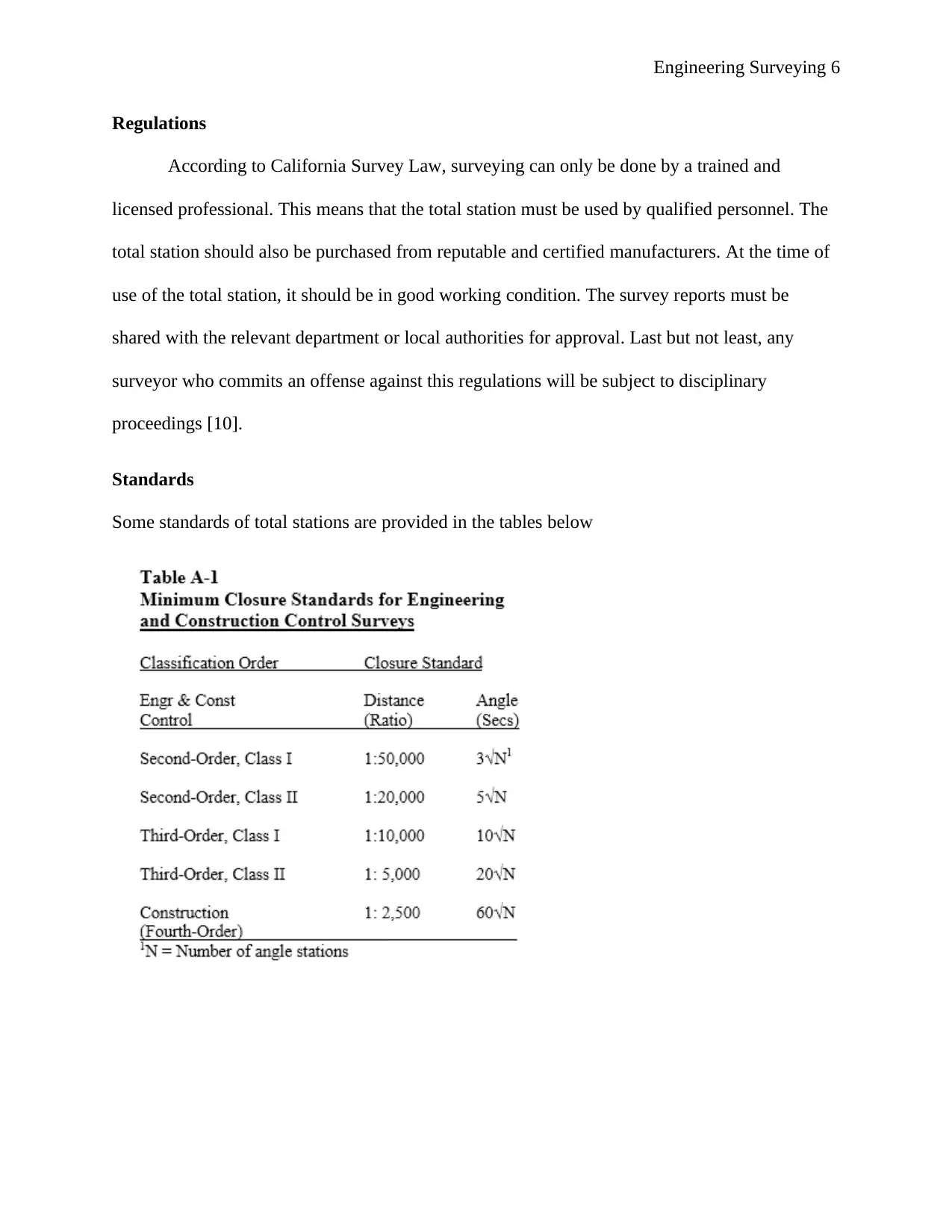
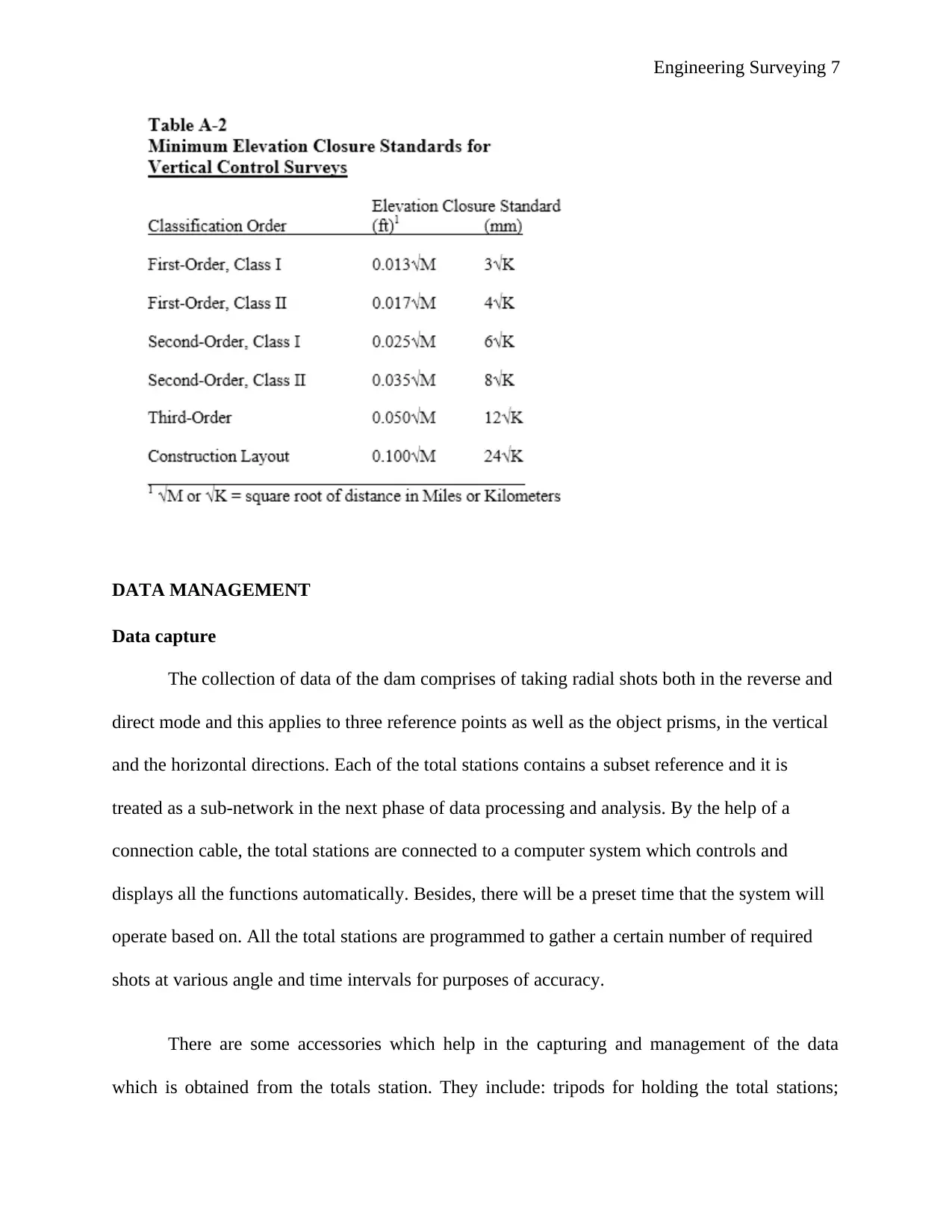
Standards
Some standards of total stations are provided in the tables below
Regulations
According to California Survey Law, surveying can only be done by a trained and
licensed professional. This means that the total station must be used by qualified personnel. The
total station should also be purchased from reputable and certified manufacturers. At the time of
use of the total station, it should be in good working condition. The survey reports must be
shared with the relevant department or local authorities for approval. Last but not least, any
surveyor who commits an offense against this regulations will be subject to disciplinary
proceedings [10].
Standards
Some standards of total stations are provided in the tables below
⊘ This is a preview!⊘
Do you want full access?
Subscribe today to unlock all pages.
Trusted by 1+ million students worldwide
Engineering Surveying 7
DATA MANAGEMENT
Data capture
The collection of data of the dam comprises of taking radial shots both in the reverse and
direct mode and this applies to three reference points as well as the object prisms, in the vertical
and the horizontal directions. Each of the total stations contains a subset reference and it is
treated as a sub-network in the next phase of data processing and analysis. By the help of a
connection cable, the total stations are connected to a computer system which controls and
displays all the functions automatically. Besides, there will be a preset time that the system will
operate based on. All the total stations are programmed to gather a certain number of required
shots at various angle and time intervals for purposes of accuracy.
There are some accessories which help in the capturing and management of the data
which is obtained from the totals station. They include: tripods for holding the total stations;
Paraphrase This Document
Need a fresh take? Get an instant paraphrase of this document with our AI Paraphraser
Engineering Surveying 8
tribrachs – which helps in achieving the accuracy; reflectors – these are high-quality glass for
coating and longevity; batteries – which powers the instrument; micro SD storage system for
storing the data collected; data transfer cables; bags and carriers for securing the instruments;
wye piece lenses for highest performance; poles for the stability of weight; and carriers for high
accuracy [11].
Data Processing
A total station processes and analyzes surveyed data using computational methods. The
computations are done using an external device known as data logger or data collector. The
device is designed such that it keeps records of all the data that is being analyzed. It also has an
inbuilt microprocessor for data processing. The microprocessor has the capability of averaging
numerous observations. It can compute x-y-z coordinates and horizontal distance using
horizontal and vertical angle measurements, slope distance measurement, and instrument and
target height measurements. The total station can also be integrated with Global Navigation
Satellite System that is used to measure coordinates of the surveyed points. Additionally, total
stations are equipped with Geographic Information System (GIS) and Global Positioning System
(GPS) that enables precise mapping of the points that are being surveyed [12].
Presentation
A total station presents data using electronic display. The operator has to press respective
keys depending on the data he/she wants displayed. The equipment can display horizontal &
vertical distances, horizontal & vertical angles, three coordinates of surveyed points; and
elevation deviations between surveyed points [13]. It can also store the data in an electronic
notebook or send it directly to a computer connected to it.
Engineering Surveying 9
Quality control
A total station is a real-time equipment integrated with an onboard computer that enables
live feedback. The onboard computer uses real-time measurements to adjust or resolve data and
set the desired construction points. This ensures that high quality and accuracy of the data
collected by a total station.
References
[1] I. Elkhrachy, "Importance of Surveying to Civil Engineers and Some Practical Examples," Najra
University, Najran, Saudi Arabia, 2015.
[2] J. O. Wao and I. Flood, "The role of quantity surveyors in the international construction arena,"
International Journal of Construction Management, vol. 16, no. 2, pp. 126-137, 2016.
[3] Time Team America, "Total Station, Totally Cool," Time Team America, 11 September 2012.
[Online]. Available: http://www.pbs.org/time-team/experience-archaeology/total-station-totally-
cool/. [Accessed 13 May 2018].
[4] C. Whitaker, M. Duffy and A. Chrzanowski, "Design of an Automated Dam Deformation Monitoring
System: A Case Study," Journal of Geospatial Engineering, vol. 2, no. 1, pp. 23-34, 1998.
[5] G. T. Orlob and M. R. Lindorf, "Cost of Water Treatment in California," American Water Works
Association, vol. 50, no. 1, pp. 45-55, 1958.
[6] G. D. Libecap, "Chinatown revisited: Owens Valley and Los Angeles - Bargaining Costs and Fairness
Perceptions of the First Major Water Rights Exchange," Journal of Law, Economics & Organization,
vol. 25, no. 2, pp. 311-338, 2008.
[7] J. Jezko, "Calibration of Surveying Instruments and Tools – Means to the Quality Increase of
Deformation Measurements," Journal of Sustainable Mining, vol. 13, no. 4, pp. 17-22, 2014.
[8] Department of Transportation, "Chapter 3 Surveying Measurements," State of New Jersey, 8 March
2007. [Online]. Available:
⊘ This is a preview!⊘
Do you want full access?
Subscribe today to unlock all pages.
Trusted by 1+ million students worldwide
Engineering Surveying 10
http://www.state.nj.us/transportation/eng/documents/survey/Chapter3.shtm. [Accessed 13 May
2018].
[9] State of California, "Professional Land Surveyors' Act," State of California, California, 2017.
[10] State of California, "Business and Professions Code," State of California, California, 2008.
[11] D. D. Kim, R. B. Langley, D. Bond and A. Chrizanowski, "Local deformation monitoring using GPS in
an open pit mine: an inital study," GPS Solutions, vol. 7, no. 3, pp. 176-185, 2003.
[12] S. Padhi, "Working Knowledge of a Total Station - Essential Skill for Civil Engineering Students,"
Skyfi Labs, 24 May 2014. [Online]. Available: http://www.skyfilabs.com/blog/working-knowledge-
of-a-total-station. [Accessed 13 May 2018].
[13] The Constructor, "What is a Total Station?," The Constructor, 2017. [Online]. Available:
https://theconstructor.org/surveying/total-station-operation-uses-advantage/6605/. [Accessed 13
May 2018].
[14] D. J. Ztland, Conflict and Cooperation Within an Organization: A Case Study of the Metropolitan
Water District of Southern California, Davis: University of California, 2008.
1 out of 10
Related Documents


Your All-in-One AI-Powered Toolkit for Academic Success.
+13062052269
info@desklib.com
Available 24*7 on WhatsApp / Email
![[object Object]](/_next/static/media/star-bottom.7253800d.svg)
Unlock your academic potential
Copyright © 2020–2026 A2Z Services. All Rights Reserved. Developed and managed by ZUCOL.