Transportation Engineering: Traffic and Geotechnical Assessment
VerifiedAdded on 2023/01/12
|13
|1897
|74
Report
AI Summary
This report presents a comprehensive traffic assessment and geotechnical analysis for a proposed road design, drawing parallels to the traffic flow and design of Marmion Avenue. The assessment includes hourly traffic volume data, analysis of vehicle and pedestrian movement, and recommendations for a 3-lane dual carriageway design with a 60 kph speed limit. The report also details the required services, including electricity, water, and sewerage, and specifies the providers for each. Furthermore, it provides a detailed overview of the geotechnical information of the area, focusing on the alluvial soils found in the region, including soil appearance, magnetic features, and results from various tests such as effective stress tests, triaxial tests, permeability tests, shear tests, performance tests, and chemical tests. The report concludes by emphasizing the importance of considering these factors for a safe and efficient road design.
TRANSPORTATION ENGINEERING
By Name
Course
Instructor
Institution
Location
Date
By Name
Course
Instructor
Institution
Location
Date
Paraphrase This Document
Need a fresh take? Get an instant paraphrase of this document with our AI Paraphraser
TRAFFIC ASSESSMENT
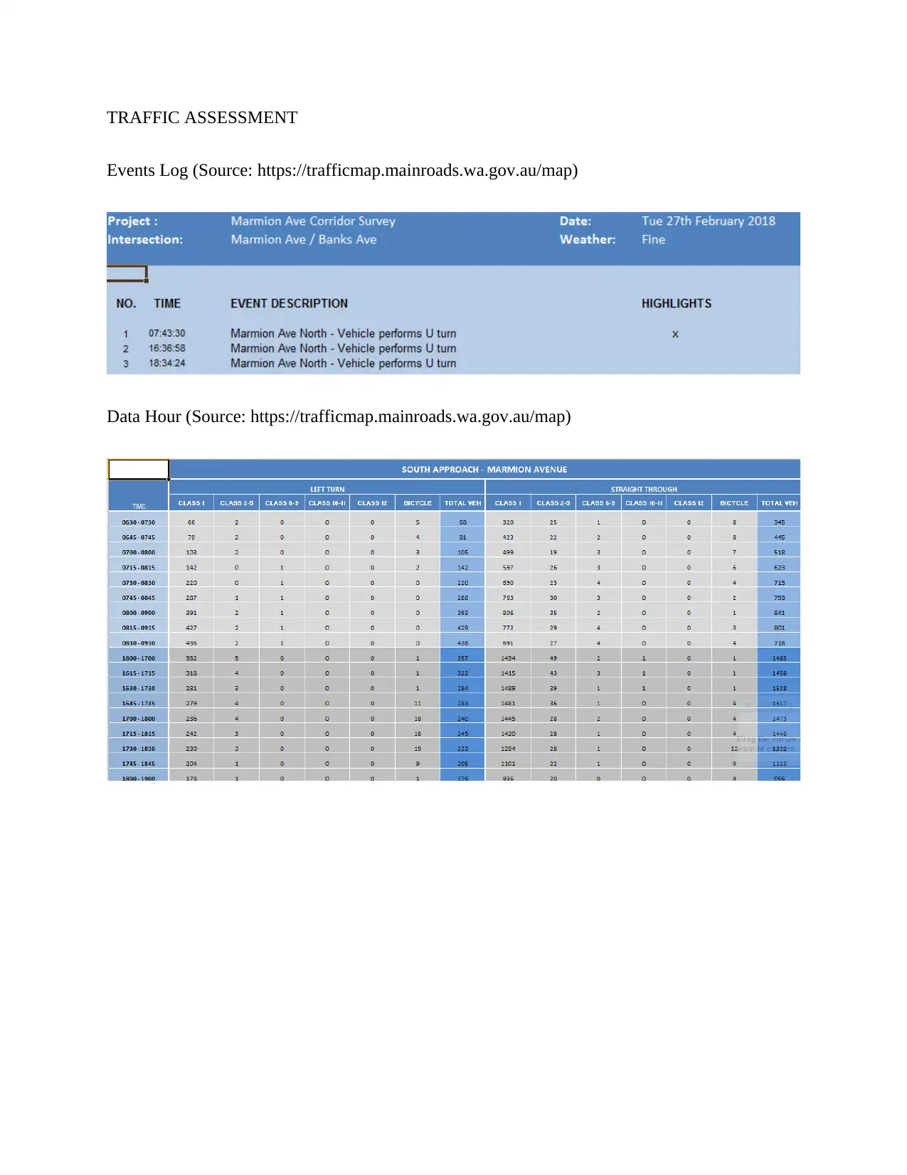
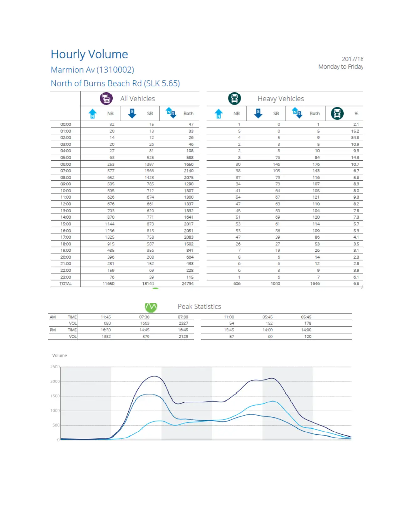
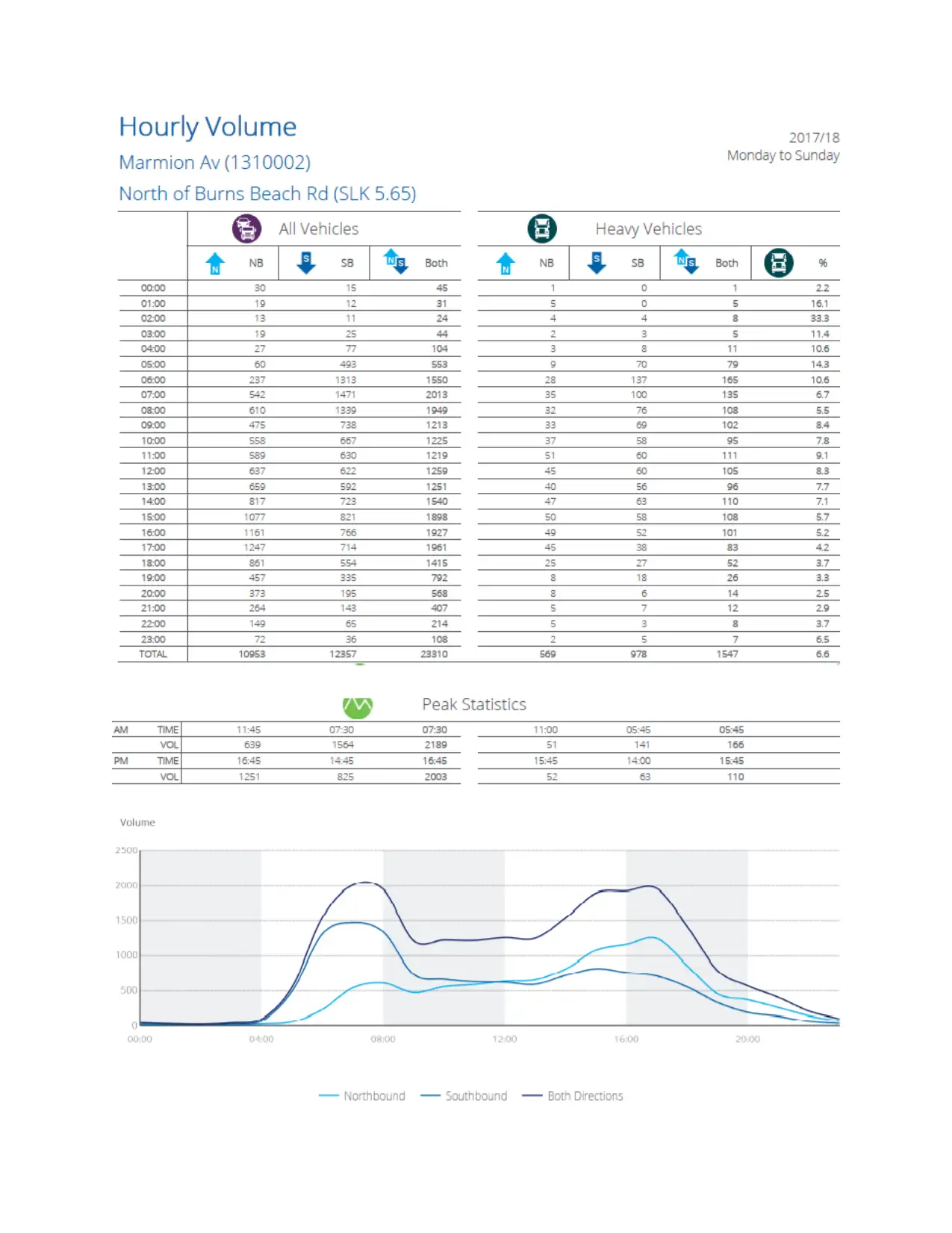
Events Log (Source: https://trafficmap.mainroads.wa.gov.au/map)
Data Hour (Source: https://trafficmap.mainroads.wa.gov.au/map)
Events Log (Source: https://trafficmap.mainroads.wa.gov.au/map)
Data Hour (Source: https://trafficmap.mainroads.wa.gov.au/map)

The data on the traffic flow assessment on Marmion Avenue is as shown above as well as the
one included in the appendix section. The data is illustrative of the flow of vehicles, pedestrians
and the analysis of such flows on an hourly basis. Based on the analysis conducted, a
recommendation is made that the design of the proposed road be to the very standard as the one
used for Marmion Avenue including the traffic speed limit of 60 kph (Jamson, Hibberd & Merat,
2015). The proposed road should provide for pedestrian and vehicle movement in a manner that
is not only harmonious but also safe for use. The proposal below illustrates a 3 lane dual carried
⊘ This is a preview!⊘
Do you want full access?
Subscribe today to unlock all pages.
Trusted by 1+ million students worldwide
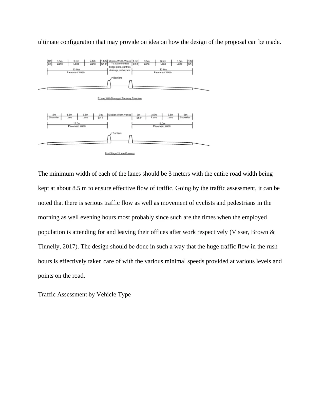
ultimate configuration that may provide on idea on how the design of the proposal can be made.
The minimum width of each of the lanes should be 3 meters with the entire road width being
kept at about 8.5 m to ensure effective flow of traffic. Going by the traffic assessment, it can be
noted that there is serious traffic flow as well as movement of cyclists and pedestrians in the
morning as well evening hours most probably since such are the times when the employed
population is attending for and leaving their offices after work respectively (Visser, Brown &
Tinnelly, 2017). The design should be done in such a way that the huge traffic flow in the rush
hours is effectively taken care of with the various minimal speeds provided at various levels and
points on the road.
Traffic Assessment by Vehicle Type
Paraphrase This Document
Need a fresh take? Get an instant paraphrase of this document with our AI Paraphraser
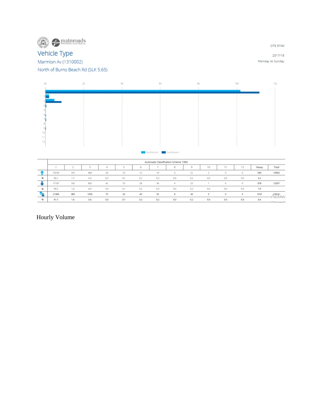
Hourly Volume
⊘ This is a preview!⊘
Do you want full access?
Subscribe today to unlock all pages.
Trusted by 1+ million students worldwide
Paraphrase This Document
Need a fresh take? Get an instant paraphrase of this document with our AI Paraphraser
Source: https://trafficmap.mainroads.wa.gov.au/map
SERVICES
Among the various services in the area which would be used or needed during the design and
construction of the proposed road would include electricity, water and sewages services
alongside. These services are needed for the purposes of ensuring the construction of the road
meets the demands of the users besides ensuring continued sustainability of the region. Water as
well as sewerage services are under the control of the various local and municipal authorities
who ensure there is continuous and adequate supply of the resource. Water and sewerage will be
supplied and regulated by the National Water and Sanitation Company which is a state owned
corporation. The use of the national company in the supply of the service would ensure the
process is as cost effective as possible besides being efficient in terms of service delivery.
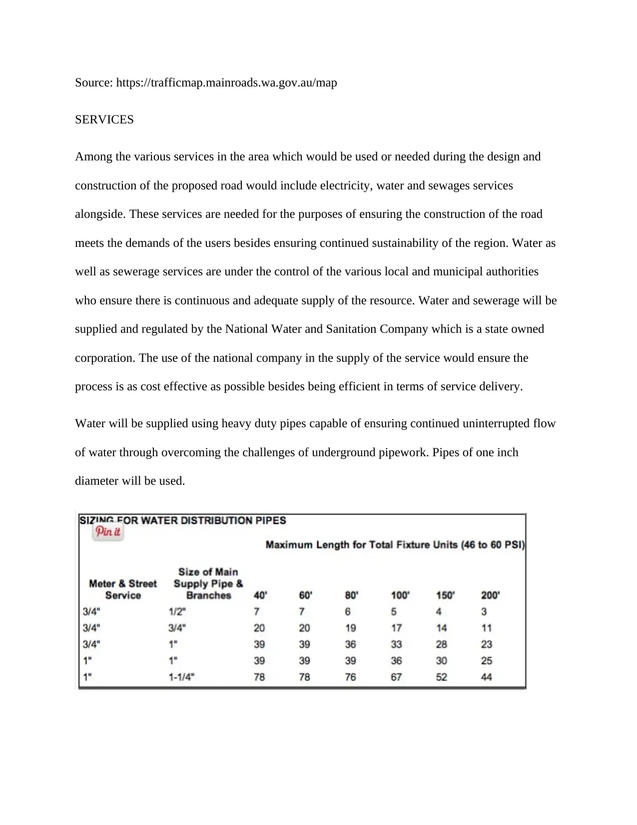
Water will be supplied using heavy duty pipes capable of ensuring continued uninterrupted flow
of water through overcoming the challenges of underground pipework. Pipes of one inch
diameter will be used.
SERVICES
Among the various services in the area which would be used or needed during the design and
construction of the proposed road would include electricity, water and sewages services
alongside. These services are needed for the purposes of ensuring the construction of the road
meets the demands of the users besides ensuring continued sustainability of the region. Water as
well as sewerage services are under the control of the various local and municipal authorities
who ensure there is continuous and adequate supply of the resource. Water and sewerage will be
supplied and regulated by the National Water and Sanitation Company which is a state owned
corporation. The use of the national company in the supply of the service would ensure the
process is as cost effective as possible besides being efficient in terms of service delivery.
Water will be supplied using heavy duty pipes capable of ensuring continued uninterrupted flow
of water through overcoming the challenges of underground pipework. Pipes of one inch
diameter will be used.
AGL Energy Ltd will be tasked with the responsibility of ensuring continued and steady supply
of power for the design and execution of the project. AGL Energy Ltd produces energy from the
various power stations which make use of thermal, wind power, natural gas, solar energy,
hydroelectricity, coal seam gas as well as gas storage among other sources of power. The
company is selected as it mainly supplies power from renewable energy sources which are not
only cost effective but also environmentally friendly (Shaneyfelt, Anderson, Kumar & Hunt
2017). The construction would thus play a major role in the conservation of the environment
rendering it more habitable and serving as a promoter of the sustainable development goals.
Electricity will be supplied using high strength cables capable of ensuring continued
uninterrupted flow of power.
GEOTECHNICAL INFORMATION
The soils in the region between the Mitchell Freeway extension and Marmion Avenue in the
suburb of Eglinton, City of Wanneroo is mainly clay alluvial soils that have been established to
be of good adequate strength as well as other features going by the tests that have been
conducted.
Soil appearance
Alluvial soils have a scope of highlights. The accompanying portrayals are ordinary of the
principle soil profiles utilized for vegetable generation.
Surface and shading: prairie soils
The topsoil is a dark soil to mud topsoil with moderate piece structure and pH 7.0 to 30 cm
profundity. The subsoil in the Macquarie Valley is a blocky light soil, tolerably organized with
pH 7.5 overlying profoundly plastic earthy dark soil. In the Lachlan Valley the subsoil is an
⊘ This is a preview!⊘
Do you want full access?
Subscribe today to unlock all pages.
Trusted by 1+ million students worldwide
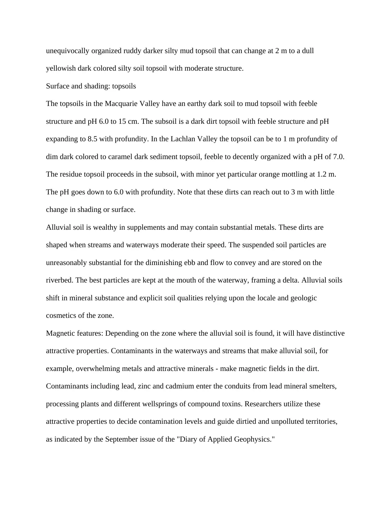
unequivocally organized ruddy darker silty mud topsoil that can change at 2 m to a dull
yellowish dark colored silty soil topsoil with moderate structure.
Surface and shading: topsoils
The topsoils in the Macquarie Valley have an earthy dark soil to mud topsoil with feeble
structure and pH 6.0 to 15 cm. The subsoil is a dark dirt topsoil with feeble structure and pH
expanding to 8.5 with profundity. In the Lachlan Valley the topsoil can be to 1 m profundity of
dim dark colored to caramel dark sediment topsoil, feeble to decently organized with a pH of 7.0.
The residue topsoil proceeds in the subsoil, with minor yet particular orange mottling at 1.2 m.
The pH goes down to 6.0 with profundity. Note that these dirts can reach out to 3 m with little
change in shading or surface.
Alluvial soil is wealthy in supplements and may contain substantial metals. These dirts are
shaped when streams and waterways moderate their speed. The suspended soil particles are
unreasonably substantial for the diminishing ebb and flow to convey and are stored on the
riverbed. The best particles are kept at the mouth of the waterway, framing a delta. Alluvial soils
shift in mineral substance and explicit soil qualities relying upon the locale and geologic
cosmetics of the zone.
Magnetic features: Depending on the zone where the alluvial soil is found, it will have distinctive
attractive properties. Contaminants in the waterways and streams that make alluvial soil, for
example, overwhelming metals and attractive minerals - make magnetic fields in the dirt.
Contaminants including lead, zinc and cadmium enter the conduits from lead mineral smelters,
processing plants and different wellsprings of compound toxins. Researchers utilize these
attractive properties to decide contamination levels and guide dirtied and unpolluted territories,
as indicated by the September issue of the "Diary of Applied Geophysics."
Paraphrase This Document
Need a fresh take? Get an instant paraphrase of this document with our AI Paraphraser
Among the conducted tests include:
Effective stress tests which involve consolidation of the soil sample to an average effective stress
as well as the undrained strength along pressure of pore water measurements.
Triaxial tests define subjecting the soil to three stresses that are positioned at right angles and the
vertical stress increased to the point of failure of the specimen. The findings of such testes are
used in the design of the required as well as filed foundations even though may as well be used
in short term stability of the underground openings as well as slopes.
Permeability tests which takes measurements of the permeability coefficient as mostly carried
out in cohesive soils with the use of triaxial apparatus (Uddin, Husain, Sozer, & Husain, 2016).
The test was used in the assessment of the compacted soils permeability in the various landfills
and construction.
Shear tests: Undrained assessments of the shear quality of soils can be estimated under various
typical anxieties. In the shear enclose disappointment is caused a foreordained plane of the dirt.
Genuine quick tests can't be made in material not completely immersed or in progressively
porous soils.
The soils shear box are permitted to merge under a vertical burden and after that sheared
gradually (Sewalkar & Seitz, 2019). The outcomes are typically utilized in appraisal of slant
security and holding divider structure.
The torque required to cause shearing of soil from twin cutting edges fixed at right points. The
test permits the estimation of shear quality for establishment plan and street asphalts. They can
aid strength of earthworks.
Performance tests: This test estimates the dry thickness of the compacted soil in relationship to
dampness content contingent upon the way of the compaction exertion. Compaction impacts the
shear quality and compressibility of the dirt and is much of the time utilized in earthworks and
street development, basically utilized as a quick test to decide the dampness reasonableness of
earthwork materials at the development stage (Schieben et al., 2019). Adjustment lines are
generally decided through a scope of dampness substance in the research facility. The MCV is
utilized to measure the compactive exertion to create close full compaction and can be
corresponded with shear quality and value of CRB.
Chemical tests
pH: proportion of the acridity/alkalinity of soil and groundwater. Solid that is liable to
exceedingly portable corrosive (low pH) water can break down quickly (Kuna, Airey & Thom,
2017). This is surveyed for solid structure.
Sulfate Content: A proportion of the sulfate substance of soil and groundwater. These sulphates
can assault solid prompting its disintegration. This is surveyed for solid structure.
⊘ This is a preview!⊘
Do you want full access?
Subscribe today to unlock all pages.
Trusted by 1+ million students worldwide
1 out of 13
Your All-in-One AI-Powered Toolkit for Academic Success.
+13062052269
info@desklib.com
Available 24*7 on WhatsApp / Email
![[object Object]](/_next/static/media/star-bottom.7253800d.svg)
Unlock your academic potential
Copyright © 2020–2026 A2Z Services. All Rights Reserved. Developed and managed by ZUCOL.