Comprehensive Analysis of Urban Heat Island Research and Solutions
VerifiedAdded on 2022/08/18
|31
|6109
|403
Report
AI Summary
This research paper delves into the multifaceted impacts of the Urban Heat Island (UHI) effect, a phenomenon where urban areas experience significantly higher temperatures than their rural counterparts. The study examines the causes of UHI, including anthropogenic heat sources, building materials, and urban morphology, and explores its negative consequences on human health, energy consumption, and climate. The research employs various modeling techniques, such as CitySim, Urban Climate Model, and artificial neural networks, to analyze UHI effects across different cities globally, with a focus on seasonal variations. The paper also investigates potential mitigation strategies, including urban planning, building design, and the use of cool surfaces. The findings highlight the critical need for proactive measures by state authorities and urban planners to address the UHI effect and promote sustainable urban development. The report provides detailed insights into modeling UHI, including various approaches to assess the effects of UHI. The research also analyzes the impact of UHI on building energy demand and explores multi-scale modeling concepts to consider UHI effects at larger urban scales. The report covers the importance of mitigation strategies for environmental protection and highlights the role of urban planning and management agencies in formulating effective solutions.
URBAN HEAT ISLAND RESEARCH
Research Paper on Urban Heat Island Research
Institution Affiliation
Name of Student
Unit Title
Due Date
1
Research Paper on Urban Heat Island Research
Institution Affiliation
Name of Student
Unit Title
Due Date
1
Paraphrase This Document
Need a fresh take? Get an instant paraphrase of this document with our AI Paraphraser
URBAN HEAT ISLAND RESEARCH
EXECUTIVE SUMMARY
Urban heat island (UHI) affects urban's ecological niche both positively and negatively, though
the negative effects outweigh the positive hence making it undesirable. The negative impacts of
UHI mostly affect human health conditions, climate, and environmental surroundings. Quite a
number of research and studies have been conducted in this field. However, most of these studies
had much resemblance as the scholars used almost the same methodology of education, thus
giving almost giving similar outcomes. This research paper tends to take a different approach in
analyzing different cities through correlation, regression, and parametric statistical analysis to
find the most efficient and effective mitigation strategies for the adverse effects of the urban heat
island. Traversing through different cities around the globe, this paper expresses a dynamic
mechanism on the various impacts of UHI through different seasons. The outcome of analysis
proves that UHI is mostly experienced during winter and summer, but no doubt, the effects of
UHI can still be felt in spring or autumn. The research considered the use and analysis of various
models of UHI, such as the CitySim model, Urban climate model (UC), artificial neural network
model (ANN), MesoScale mode, city energy simulation models, etc.
2
URBAN HEAT ISLAND RESEARCH
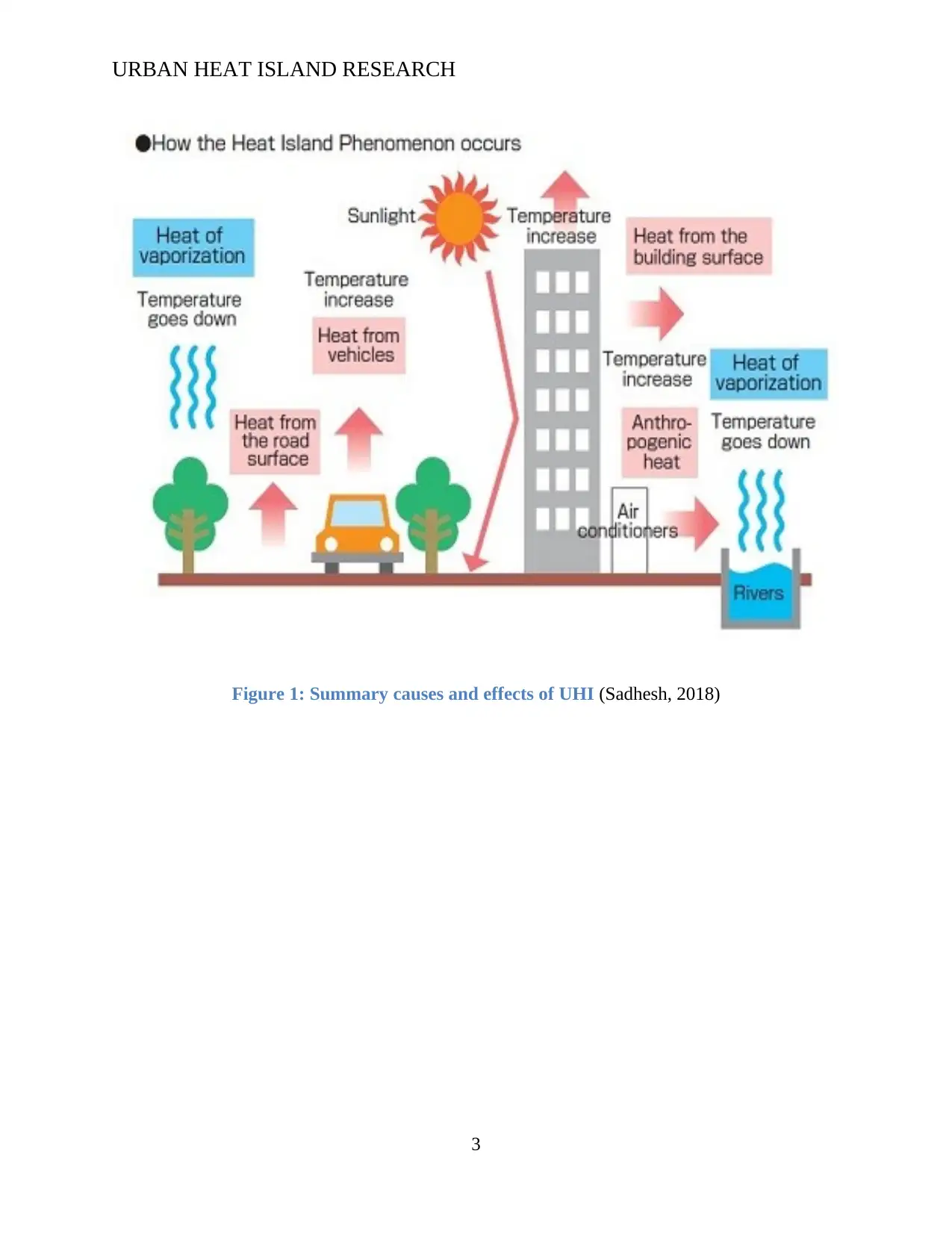
Figure 1: Summary causes and effects of UHI (Sadhesh, 2018)
3
Figure 1: Summary causes and effects of UHI (Sadhesh, 2018)
3
⊘ This is a preview!⊘
Do you want full access?
Subscribe today to unlock all pages.
Trusted by 1+ million students worldwide
URBAN HEAT ISLAND RESEARCH
TABLE OF CONTENTS
Executive summary..........................................................................................................................i
List of figures..................................................................................................................................iv
Introduction......................................................................................................................................5
Research objective.......................................................................................................................9
Literature review..............................................................................................................................9
Understanding of the urban heat island.....................................................................................11
Modeling of Urban Heat Island.................................................................................................14
Causes and effects of Urban Heat Island...................................................................................16
Adaptation and mitigation.............................................................................................................19
Urban Cities Modeling..................................................................................................................20
Urban climate modelling...............................................................................................................21
Building energy modeling.............................................................................................................23
Modeling interaction and modeling approaches........................................................................23
Conclusion.....................................................................................................................................25
References......................................................................................................................................27
4
Paraphrase This Document
Need a fresh take? Get an instant paraphrase of this document with our AI Paraphraser
URBAN HEAT ISLAND RESEARCH
LIST OF FIGURES
Figure 1: Summary causes and effects of UHI................................................................................3
Figure 2: Map of urban thermal index across north America........................................................10
Figure 3: Map of various land using Guangzhou china.................................................................10
Figure 4: Flow diagram of how to quantify urban Heat Island.....................................................14
Figure 5: Urban heat island............................................................................................................15
Figure 6: The urban Heat Island Process.......................................................................................16
Figure 7: Process of urban canopy level........................................................................................18
Figure 8: Graphical representation of UCL...................................................................................18
Figure 9: Urban heat island effect difference in rural and urban...................................................20
Figure 10: Summary of effects of UHI..........................................................................................23
Figure 11: Illustration of UHI models...........................................................................................24
5
URBAN HEAT ISLAND RESEARCH
INTRODUCTION
Urban heat island refers to the effects that are associated with the formation and development of
urban centers and urbanization in general. The impact of urban heat island is experienced in the
urban centers where the thermal condition of towns is much higher than that in the suburbs. The
disparity in temperature is caused by the many activities that take place in urban centers ranging
from heat emitted by the household chimney, motor vehicles, factories, air conditioning systems,
and heat from hotels and restaurants within the city. These items consume a lot of heat energy
and, in turn, release heat into the atmosphere raising the temperature in the town (Santamouris.,
2014). The presence of tall superstructures and sky creepers in urban areas obstruct the wind and
airflow; therefore, reducing the speed of wind hence exacerbated the heat island effect in towns.
The effect of urban heat island has been more rampant in the past few years due to the rapid
development of urban structures and urbanization of towns. Another reason for the increases
urban heat island effect is the industrialization and centralization concepts where industries are
more concentrated in a confined location. Each factory releasing emitting heat as a result of
manufacturing or production processes increases the temperature of the area, thus causing urban
heat islands in those regions (Mirzaei., 2015). Weather conditions also have an impact on the
urban heat island as extremely hot weather conditions affect the work rate of a human and can
cause health complications and, in the worse scenario, cause death as a result of heatstroke.
6
⊘ This is a preview!⊘
Do you want full access?
Subscribe today to unlock all pages.
Trusted by 1+ million students worldwide
URBAN HEAT ISLAND RESEARCH
Most parts of the world's energy consumption are in the cooling and heating of structures and
buildings. This implies that in areas with a dense population of structural buildings consume a lot
of energy in heating buildings and at the same time, release a lot of heat as a result of cooling
these buildings. Heat exchange between buildings and the proximity of urban structures hinders
the circulation of air; therefore, these released hot gases are retained in the atmosphere rising
temperatures (Guo et al., 2015). With the fast-growing urbanization, the minimization of
buildings' energy consumption in towns has a tremendous advantage in reducing island heat
effect and proves potential in energy savings. The difference in temperature conditions in urban
areas and rural areas is mainly attributed to the urban heat island (UHI) effect caused by tall
structures in urban areas. The difference in wind speed is as a result of wind being obstructed and
sheltered by urban sky creepers. Recent research to establish the physiological correlation that is
derived from similarity patterns between height counters and isotherms showed that UHI
possesses a cliff (region of difference) at the urban-rural fringe in adjacent areas to urban cities
(Debbage and Shepherd., 2015).
The effects of urban heat island is a global challenge, as the heating and cooling phenomenon
occurs to almost all urban centers and is caused by constant constructions in urban areas and
human economic activities in these regions. Research also showed that urban heat island effects
are mostly caused by heat released from buildings, underlying surface, population density,
vegetation cover, and weather conditions.
According to the United States environmental protection agency, continuous development in
structural buildings, construction of roads, and development of other infrastructures cause
changes in the landscape and vegetation cover, leaving the land open making the land than were
once moist and permeable dry and impermeable (Zhou et al., 2014). These eventually cause
7
Paraphrase This Document
Need a fresh take? Get an instant paraphrase of this document with our AI Paraphraser
URBAN HEAT ISLAND RESEARCH
changes in the climatic condition in urban areas, making cities warmer than the rural suburbs
forming an island of increasing temperature in the landscape.
City structures that include buildings, structural morphology, anthropogenic surface heat released
by automobiles, and ventilation equipment such as air conditioning are the most contributing
factors to the increasing temperature in urban centers, causing heat island. These conditions
eventually increase the building’s energy consumption as the system provides comfortability
inside buildings through the use of heat exchangers or refrigerators and also causes air pollution.
Prolonged effects of urban heat island cause greenhouse gas emission that negatively impacts on
human and animal health. Due to urban densification, increased anthropogenic heat, and decline
in vegetation cover, Intragovernmental Panel on Climate change in 2014 conducted research
aimed at finding mitigation plans and strategies that would help in minimizing the emission of
greenhouse gas effects in urban areas (Li, Bou-Zeid and Oppenheimer., 2014).
In relation to the cases mentioned above and the effects of urban heat island UHI. It is crucial for
state authorities and urban management together with urban planning agencies to formulate the
best alternative mitigation strategies through the formulation of regulations, better equipment
tools, and guidelines to offer protection to the urban environment (Santamouris ert al., 2015).
The primary objective of this report is to have a critical analysis of urban heat island,
understanding major contributing factors, dire effects, and possible mitigation strategies that best
overcome the urban heat island in metropolitan cities.
8
URBAN HEAT ISLAND RESEARCH
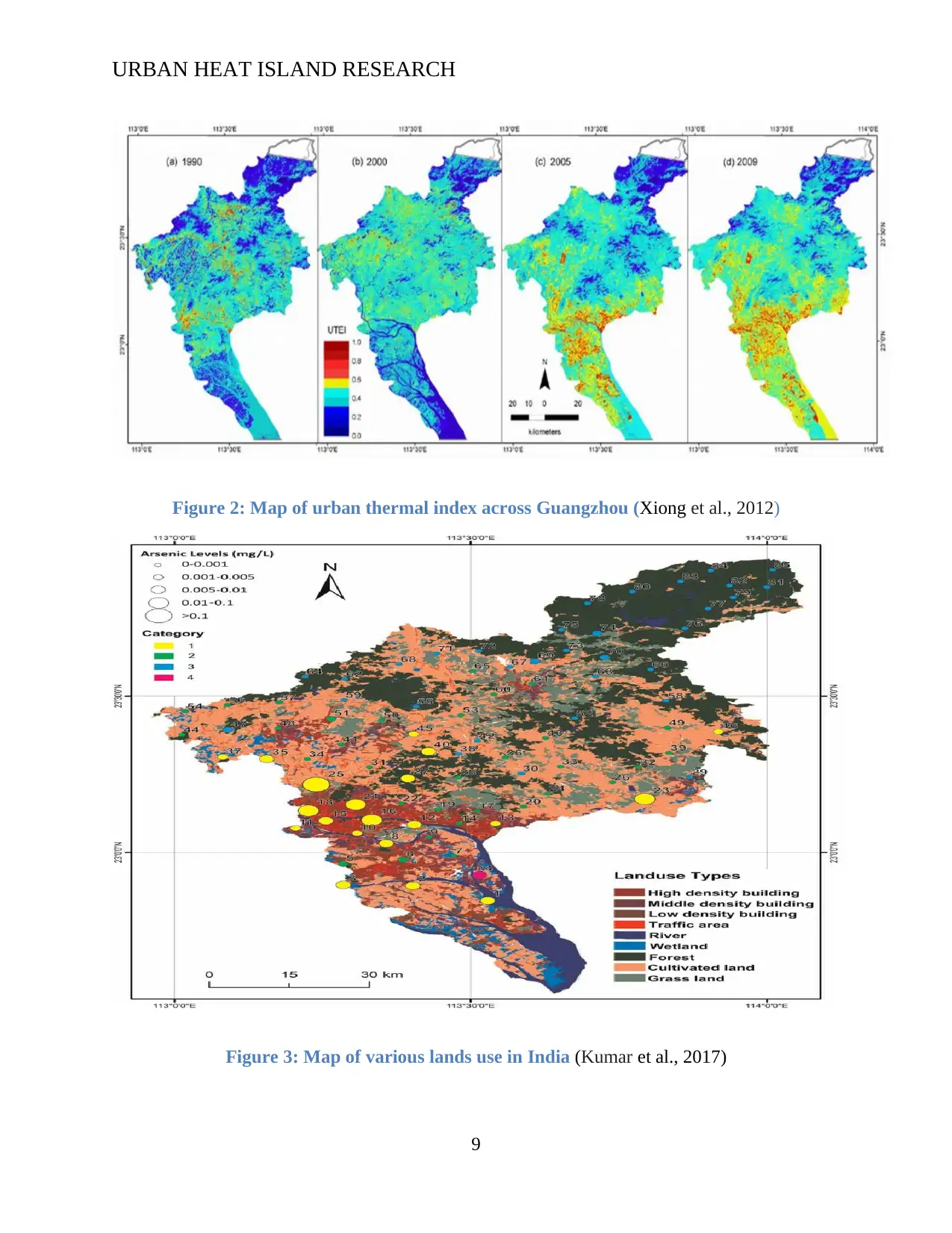
Figure 2: Map of urban thermal index across Guangzhou (Xiong et al., 2012)
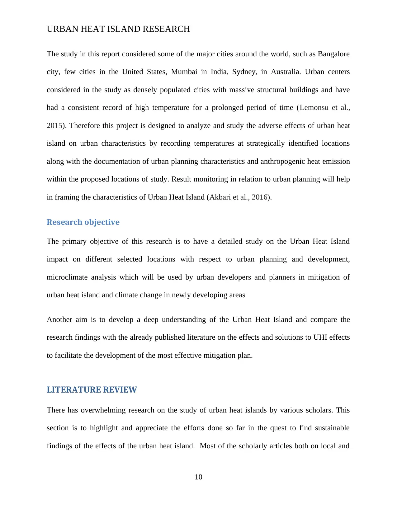
Figure 3: Map of various lands use in India (Kumar et al., 2017)
9
Figure 2: Map of urban thermal index across Guangzhou (Xiong et al., 2012)
Figure 3: Map of various lands use in India (Kumar et al., 2017)
9
⊘ This is a preview!⊘
Do you want full access?
Subscribe today to unlock all pages.
Trusted by 1+ million students worldwide
URBAN HEAT ISLAND RESEARCH
The study in this report considered some of the major cities around the world, such as Bangalore
city, few cities in the United States, Mumbai in India, Sydney, in Australia. Urban centers
considered in the study as densely populated cities with massive structural buildings and have
had a consistent record of high temperature for a prolonged period of time (Lemonsu et al.,
2015). Therefore this project is designed to analyze and study the adverse effects of urban heat
island on urban characteristics by recording temperatures at strategically identified locations
along with the documentation of urban planning characteristics and anthropogenic heat emission
within the proposed locations of study. Result monitoring in relation to urban planning will help
in framing the characteristics of Urban Heat Island (Akbari et al., 2016).
Research objective
The primary objective of this research is to have a detailed study on the Urban Heat Island
impact on different selected locations with respect to urban planning and development,
microclimate analysis which will be used by urban developers and planners in mitigation of
urban heat island and climate change in newly developing areas
Another aim is to develop a deep understanding of the Urban Heat Island and compare the
research findings with the already published literature on the effects and solutions to UHI effects
to facilitate the development of the most effective mitigation plan.
LITERATURE REVIEW
There has overwhelming research on the study of urban heat islands by various scholars. This
section is to highlight and appreciate the efforts done so far in the quest to find sustainable
findings of the effects of the urban heat island. Most of the scholarly articles both on local and
10
Paraphrase This Document
Need a fresh take? Get an instant paraphrase of this document with our AI Paraphraser
URBAN HEAT ISLAND RESEARCH
international context are quite extensive and had much focus on the mechanical aspect of the
urban heat island in urban centers, under these studies the correlation has been made in reference
to Normalized Difference Vegetation Index NDVI and the surface temperature (Reshmi et al,
2018). By definition, urban heat island is experienced when there is temperature difference
recorded in urban regions and rural regions on the same locality. There has been quite a number
of UHI evaluation phenomenon by different scholars giving a variety of suggestions and
recommendations on how to mitigate challenges that come with urban heat island. However, the
difference in this paper is that it aims at highlighting both direct and indirect influence of UHI in
different urban areas, using comparative analysis to give a one-best fit all solution to challenges
and effects caused by these temperature differences between rural suburbs and urban centers
(Peng et al., 2018).
United Nations in 2013 identified that the rate at which people were migrating from rural to
urban areas was fast increasing, and acknowledged that globalization and urbanization was an
upward trend. United nation’s report also projected that the number of people living in urban
centers would shoot to over 68% of the entire world population by 2050, meaning that as time
goes by the effects of urban heat island will continue to rise if most appropriate and effective
mitigation strategies shall not be established (Qin and Liao, 2016). However, the movement of
people from rural to urban is not something that can easily be regulated or even stopped since
many moves to urban centers in pursuit of a better life through employment opportunities. Some
for the business venture; therefore, most of the findings and recommendation from previous
scholars seems to be impractical and unrealistic.
Asian and African countries have been the key stakeholders in these research findings as
governments and ruling authorities in Africa, and Asia depends on the mitigation strategies to
11
URBAN HEAT ISLAND RESEARCH
help in advance mitigation preparations as more industrialization and urbanization is yet
expected to be experienced on Asia and Africa, as United Nations suggests that some countries
in Africa would have four-fold population increase in their urban centers by 2050 (Awumbila,
2017).
A case study conducted in Bangkok, Thailand, revealed that the rate of urbanization between
1983- 2010 was the key contributor or significant factor that influences temperature rise in cities
with dense population and many necessary infrastructures. Urbanization, despite being a good
gesture of infrastructural development, has effects not only on the temperature balance and
emission of greenhouse gases to the environment but it also affects the ocean breeze patterns in
coastal cities (Ongsomwang et al, 2018). The climatic research unit CRU of the United Kingdom
meteorological department and intergovernmental planetary climate change of the United States
showed that the earth's atmosphere warms by 0.7 to 0.9oC since the 19th century (Pattnayak et al,
2017).
Understanding of the urban heat island
A temporal study on dynamics of urban heat island, conducted in Singapore in 2010, showed that
the peak of urban heat island occurs between 5-6 hours in the evening after sunset and that urban
heat intensity can reach a maximum of approximately 70C when in ideal climatically conditions
(Xu et al., 2016). From this case study, it was generally concluded that the maximum intensity of
UHI is experienced mostly during dry seasons and the period of southwest monsoon. While the
UH intensity being lowest during wet seasons or northeast monsoon period.
12
⊘ This is a preview!⊘
Do you want full access?
Subscribe today to unlock all pages.
Trusted by 1+ million students worldwide
1 out of 31


Your All-in-One AI-Powered Toolkit for Academic Success.
+13062052269
info@desklib.com
Available 24*7 on WhatsApp / Email
![[object Object]](/_next/static/media/star-bottom.7253800d.svg)
Unlock your academic potential
Copyright © 2020–2026 A2Z Services. All Rights Reserved. Developed and managed by ZUCOL.