ELEC 30006 - Weather Radar Principles and Applications Case Study 2018
VerifiedAdded on 2023/06/13
|31
|7139
|449
Case Study
AI Summary
This case study provides an overview of weather radar principles and applications, focusing on Doppler radar technology and its use in weather forecasting and windshear detection. The study details the methodology used for weather data analysis, including data collection, analysis using the ANFIS editor in MATLAB, and error calculation. It includes a literature review covering windshear detection radars, the Advanced Weather Interactive Processing System (AWIPS), and other relevant technologies. The case study further classifies radar systems, discusses sustainability aspects, and touches on the importance of accurate weather information for various applications. Desklib offers this and other solved assignments to aid students in their studies.
Running head: WEATHER RADAR PRINCIPLES AND APPLICATIONS
WEATHER RADAR PRINCIPLES AND APPLICATIONS
Name of the student:
Name of the university:
Author note:
WEATHER RADAR PRINCIPLES AND APPLICATIONS
Name of the student:
Name of the university:
Author note:
Paraphrase This Document
Need a fresh take? Get an instant paraphrase of this document with our AI Paraphraser
1
WEATHER RADAR PRINCIPLES AND APPLICATIONS
Table of Contents
Chapter 1: Introduction....................................................................................................................2
Chapter 2: Methodology..................................................................................................................3
Chapter 3: Literature review:...........................................................................................................7
Chapter 4: Classification of radar and sustainability aspect of the project:..................................13
Chapter 5: poster design................................................................................................................23
Chapter 6: Conclusion...................................................................................................................24
References:....................................................................................................................................26
Appendix:......................................................................................................................................28
2
WEATHER RADAR PRINCIPLES AND APPLICATIONS
Chapter 1: Introduction
Radar refers to the object detection system that makes use of the radio waves for the
purpose of determining the range, angle or velocity associated with an object. Radar system
consists of transmitter that radiates the radio wave, commonly referred to as radio signal. The
signal is emitted in some predefined direction. When the signal encounters an object the signal is
reflected or scattered in random directions. However some portion of the signal that is not
reflected back or the portion that does not caters following a collision with an object is absorbed
by the object. The portion of the signal that is reflected back is very important as it is responsible
for the radar to perform the work for which the system is installed (Radartutorial.eu 2018). Radar
receiver is located near the transmitter to catch the reflected signal. However in some cases the
receiver may be situated far from the receiver. The weak absorption of radio waves helps the
radar to detect the objects that are located in long distances. Other EM waves like visible light,
infrared light and ultraviolet light too faces strong attenuation within this long distances.
The weather radar helps to detect rain in the atmosphere. It emits microwave pulses
which are reflected back by the raindrops. The reflected signal from the raindrops is then
measured by the receiver. The reflected signal gives a lot of useful information about the weather
condition. The intensity of the reflected signal is particularly of major interest. It gives
information about the intensity of the rain (Wright, D.B., Nielsen, J.E. and Rasmussen, M.R.,
2017). The more intense the rain is the more intense the reflected signal will be. Thus by
analysing the reflected signal and particularly the intensity factor of the signal, it can be
interpreted whether the rain is intense or not. Another factor that is measured is the time of
travelling. The time that the reflected signal takes to complete the distance between the targeted
⊘ This is a preview!⊘
Do you want full access?
Subscribe today to unlock all pages.
Trusted by 1+ million students worldwide
3
WEATHER RADAR PRINCIPLES AND APPLICATIONS
object and receiver is calculated. The time that the reflected signal takes helps to measure the
distance of the rain like how far the rain is at that instance of time.
Doppler weather radar has become increasingly popular in recent years due to its
portability and effectiveness in weather prediction. Doppler radar is an advanced and efficient
weather radar system. The radar works on the principle Doppler Effect. According to the theory
of Doppler effect, based on the relative distance of moving object from the source , the intensity
of the sound waves originated from the moving object also changes, the closer the object to the
source, the more intense the sound waves seem to be to the source (Westbrook, J.K. and Eyster,
R.S., 2017). The same concept is applied here. Instead of the sound wave, here the intensity of
the reflected signal from the rain droplets is measured which gives an estimation of the speed of
the rain droplets. The intensity of the rain droplets can also be estimated. The information related
to the speed and intensity of the rain droplets plays an important role in weather prediction and
serves the information for public use.
Chapter 2: Methodology
Steps of the research methodology:
Step1: choice of weather variables:
Weather data is vast in amount as it contains information about the weather which often
ranges from several weeks, months, to several years. Hence it is a huge challenge to analyse the
collected data which is so vast in amount. In order to be able to analyse the data it is important to
choose the correct analysis tools. It is also important to choose the correct weather variables and
also the input and output parameters have to be defined as it has a significant effect on the
Paraphrase This Document
Need a fresh take? Get an instant paraphrase of this document with our AI Paraphraser
4
WEATHER RADAR PRINCIPLES AND APPLICATIONS
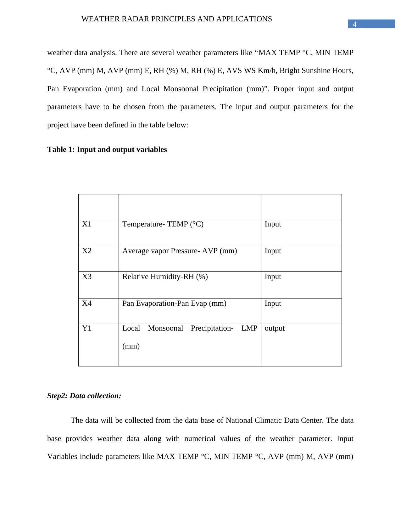
weather data analysis. There are several weather parameters like “MAX TEMP °C, MIN TEMP
°C, AVP (mm) M, AVP (mm) E, RH (%) M, RH (%) E, AVS WS Km/h, Bright Sunshine Hours,
Pan Evaporation (mm) and Local Monsoonal Precipitation (mm)”. Proper input and output
parameters have to be chosen from the parameters. The input and output parameters for the
project have been defined in the table below:
Table 1: Input and output variables
X1 Temperature- TEMP (°C) Input
X2 Average vapor Pressure- AVP (mm) Input
X3 Relative Humidity-RH (%) Input
X4 Pan Evaporation-Pan Evap (mm) Input
Y1 Local Monsoonal Precipitation- LMP
(mm)
output
Step2: Data collection:
The data will be collected from the data base of National Climatic Data Center. The data
base provides weather data along with numerical values of the weather parameter. Input
Variables include parameters like MAX TEMP °C, MIN TEMP °C, AVP (mm) M, AVP (mm)
WEATHER RADAR PRINCIPLES AND APPLICATIONS
weather data analysis. There are several weather parameters like “MAX TEMP °C, MIN TEMP
°C, AVP (mm) M, AVP (mm) E, RH (%) M, RH (%) E, AVS WS Km/h, Bright Sunshine Hours,
Pan Evaporation (mm) and Local Monsoonal Precipitation (mm)”. Proper input and output
parameters have to be chosen from the parameters. The input and output parameters for the
project have been defined in the table below:
Table 1: Input and output variables
X1 Temperature- TEMP (°C) Input
X2 Average vapor Pressure- AVP (mm) Input
X3 Relative Humidity-RH (%) Input
X4 Pan Evaporation-Pan Evap (mm) Input
Y1 Local Monsoonal Precipitation- LMP
(mm)
output
Step2: Data collection:
The data will be collected from the data base of National Climatic Data Center. The data
base provides weather data along with numerical values of the weather parameter. Input
Variables include parameters like MAX TEMP °C, MIN TEMP °C, AVP (mm) M, AVP (mm)
5
WEATHER RADAR PRINCIPLES AND APPLICATIONS
E, RH (%) M, RH (%) E, AVS WS Km/h, Bright Sunshine Hours, Pan Evaporation (mm) are
considered as input variables and the parameter Local Monsoonal Precipitation (mm) has been
considered as output variable. The output variable depends on the input variables as mentioned.
Bellow a sample weather data is provided. The yearly data of the North Carolina monsoon
season is separated in accordance with the Standard Meteorological Week or SMW. In the
research project, 40 years data of North Carolina monsoon season will be collected. A sample
data sheet is shown for reference:
Step3: Data analysis:
The data will be analyzed using the ANFIS editor in the MATLAB. In order to set up the
network in the ANIFS editor, at first the Sugeno ANFIS Setup has to be done and then the
ANFIS Model has to be trained.
Sugeno ANFIS Setup Model:
In order to design the network in the ANFIS editor, input data has to be loaded in the
ANFIS editor. The input data has to be separated as training, checking and testing data set.
Sample ANFIS information is:
No. of input 3
No. of output 1
No. of input Mfs: 4 2 2 4
Training of ANFIS model:
⊘ This is a preview!⊘
Do you want full access?
Subscribe today to unlock all pages.
Trusted by 1+ million students worldwide
6
WEATHER RADAR PRINCIPLES AND APPLICATIONS
The ANFIS model has to be trained with sample input data sets. The training will help
the model in learning the overall pattern after analyzing different input data of several years as
well as the yearly input data. After the training is completed, the model will be ready for
prediction.
Step4: Error calculation in the data:
In order to make effective prediction, it is important to minimize the error in the collected
data. There are various types of error calculation tolls that will be used in the experiment. The
tolls are:
Output deviations:
Calculate the error by finding the absolute difference between the observed and predicted
value of output variable.
Mean Squared Error:
It Find the squared difference between the forecasted and observed output variable and
find the average.
Root Means Squared Error:
It simply finds the square root of mean square error or MSE to calculate the error.
Paraphrase This Document
Need a fresh take? Get an instant paraphrase of this document with our AI Paraphraser
7
WEATHER RADAR PRINCIPLES AND APPLICATIONS
Chapter 3: Literature review:
1. The occurrence of windshear is regarded as one of the primary reason for the aircraft
accident. Windshear is referred to the difference of the wind speed and the direction of the wind
movement. The difference is calculated within a relatively short distance in the atmospheric
conditions. It has both the vertical and horizontal components (Hirth 2015). Horizontal shear is
particularly seen near the coast as well as across the weather front. Vertical shear is primarily
occurs somewhere near the surface though it can occur at the altitude similar to jet streams. Even
it is not very uncommon to observe the vertical windshear near the strong upper level fronts.
Since the 90s, the application of windshear detection radars got widespread attention and
several airports around the world adopted the technology commonly known as Terminal Doppler
Weather Radars or TDWR. The technology is based on the Doppler Effect. It is very much
important to collect the details of windshear in order to avoid any kind of hazards during the
aviation. Doppler weather radar helps to collect information about the windshear to effectively
schedule the flight time (Edgar and Flyvbjerg 2015). The radar collects the information about the
wind speed , wind directions and helps in analyzing information about the windshear.
The strongest windshear is seen due to the microburst, often associated with the
thunderstorm that occurs over the areas where the airport terminal is located. In a more intense
thunderstorm, intense cold air bursts towards the downward direction and get outspread near the
grounds. Abrupt and sudden change in the aircraft speed and wind direction poses threat to
aircraft safety.TWDR helps to detect low level windshear near the airport. It is much more
technologically advanced than the traditional radar system (Wison et al. 2015). The traditional
radars are useful only for monitoring the development and movement of rain areas. With the help
8
WEATHER RADAR PRINCIPLES AND APPLICATIONS
of Doppler Effect the TWDR helps in measuring the radial winds originated from the radar. The
change in wind speed and direction has a significant effect on the landing and departure of the
aircraft. TWDR is placed along the direction of aircraft in the runway so that it measures the
windshear and provides the accurate details about the measurement. The accurate measurement
is very much important because a little mistake in the calculations will have a larger impact as
far as the safety of the aircraft is concerned.
During the thunderstorm, TWWDR scans rapidly in order to detect and measure the rapid
changes in the wind speed. It is not only important to measure the rapid changes in the wind
speed and direction, fast calculations must be conducted to reflect the changes in the decision
making process about the departure and landing of the aircraft. In order to achieve that the signal
sent by the radar has to be of high quality. The signal sent by the traditional radar is not very
high quality signal. However TWDR has the capability to send signal that are of very high
quality and does not affected by high distortions and this makes the Doppler ideal for such
application where speed and accuracy has to be maintained at the same time considering the
sensitive nature of the application (Browning and Wexler 2015).
Doppler radar has been widely used in the development of the Advanced Weather
Interactive Processing System or commonly known as AWIPS. It is an advanced weather
information processing system where highly advanced and powerful processors display and
communication equipment is used. It is operated by the United States National Weather Service
or NWS.It is basically a complex network that integrates several metrological, hydrological and
satellite data collected from various weather radar or the Doppler radar to find important details
about the weather system (Birkenheuer 2015). This data, after insightful analysis, is sent to the
various weather and river forecast centers. This data are then used by the centers to gather
⊘ This is a preview!⊘
Do you want full access?
Subscribe today to unlock all pages.
Trusted by 1+ million students worldwide
9
WEATHER RADAR PRINCIPLES AND APPLICATIONS
important information about the weather conditions like humidity, temperature and various other
weather related details. This helps the centers to make accurate forecast about the weather, water
and climate conditions. In 2015, Raytheon, the architect responsible for the AWIPS revolution ,
brought the AWIPS II in the market to mark the up gradation to the system. With the AWIPS II,
several new features were added to the system which made the system even more powerful in
terms of capabilities and accuracy in the prediction. It integrated several new hardware and
software to the design to make it more powerful compared to the previous editions. It now allows
to forecast in the field and respond right from the location to deal with emergency conditions.
AWPS make the data processing automatic and accurate. In order to get details about the
weather, water and climate conditions and make effective decision based on that, the data must
be very accurate and reliable and for that very high quality radar is required to collect the
information and help the station to remain alert about the various conditions of the weather and
the climate changes (Birkenheuer 2015). In order to collect such important and sensitive data,
there should be absolute no scope of error and even if there is any that must be well within the
accepted limit. It is true that AWPS uses vey high quality of processor and analyzing tools to
collect information from the raw data. However there will be no use of those advanced system if
there is error in the collected data. The advanced analyzing tolls will only be useful if they
produce accurate information. Still it has nothing to do with the accuracy of the raw data. The
raw data has to be accurate if the result needs to correct. In order to collect accurate raw data the
radar needs to be very efficient as the data will be collected first by the radar and then only those
data can be analyzed by advanced processing systems to generate useful information from the
collected data. Doppler radar as compared to the traditional data is much more powerful and
advanced and can reflect the changes in the weather and climate very effectively, thus helps to
Paraphrase This Document
Need a fresh take? Get an instant paraphrase of this document with our AI Paraphraser
10
WEATHER RADAR PRINCIPLES AND APPLICATIONS
realize the full potentials of the analyzing tools to make predictions more correctly. The ability of
the weather radar to make correct measurement about wind conditions and the weather condition
as a whole makes it suitable in the field of agriculture for weather condition measurement.
Weather prediction plays an important role in the field of agriculture. The weather
conditions as well the climate conditions needs to be measured accurately to provide correct
assistance to the farmer for their agricultural decision. The capability of the weather radar to
measure all type of weather conditions and provide day long weather monitoring information
make the weather radar the perfect choice for agricultural applications (Friday 2014). Traditional
remote sensing devices use the natural wave. The traditional remote sensing device is also
known as the passive device. However the radar remote sensing system uses artificial wave,
hence it is known as active device. This allows the operators to select the necessary wave band as
per the need of the application and also offers flexibility in terms of choosing the correct
polarization model. The weather radar also provides information about the growth of the crops
and helps to monitor the growth effectively. The radar use the information related to the moister
content of the crop. The information about the moist content of the crop helps to measure the
growth of the crops. During the time of crop growing, the moister content is very helpful in
knowing the details about crop growth. It is impossible for traditional RS devices to measure the
moist content and hence it is not suitable for the application. However, the radar RS helps to
conduct the measurement in these conditions due to the ability of the radar to measure the moist
content.
Strom and bad weather also hampers the agricultural works. Hence accurate measurement
of the weather is necessary. Weather radar helps to collect information about the conditions of
the weather and based on that the agricultural centers monitors various factors related to the data
11
WEATHER RADAR PRINCIPLES AND APPLICATIONS
which helps them to provide assistance to the farmers and the agricultural firms. The wind
direction and speed is another important aspect of measuring the weather conditions. The
weather radar has the capability to sense the variation of wind speed. It can also measure the
direction of the wind flow. This information is sent to the centers that are assigned with the
responsibility to analyze the data as provided by the radar system. Perfect analyze of this data
helps in correct measurement of the weather conditions which in turn helps in making effective
predictions (Meischner 2015). The predictions may not be always correct and error free.
However the error can be minimized by making improvement in the data collection process itself
so that the data is very accurate and correct. In order to do that the data collection process has to
be very smart and advanced. Compared to the traditional remote sensing devices, the weather
radar is much more advanced and provides correct data about the weather condition so that data
analysis becomes more reliable and effective.
Doppler weather radar is used in the command ship. It is used to assist the satellite
launches at sea. The radar is used mainly in commercial satellite launches. It operates on board
of the command ship. The satellite is launched from a location at sea. The radar is installed on
board of the sea launch commander. The radar supports launch related activities. The radar is
also used in helping the launch team to track storm while crossing between ports. The radar is
stabilized in such a way that it can provide accurate data even if there is pitch and roll motion
exhibited by the ship. The radar also provides velocity products which helps in correcting the
speed and direction of the ship. It has major benefits in the weather prediction technique. It also
allows using the full capability of the radar in any conditions. The result does not depend on the
motion of the ship (Xiaoding 2014). Whether the ship is in motion or it is still, the accuracy of
the radar is not affected. The radar helps in obtaining full weather related data. It provides data
⊘ This is a preview!⊘
Do you want full access?
Subscribe today to unlock all pages.
Trusted by 1+ million students worldwide
1 out of 31
Related Documents


Your All-in-One AI-Powered Toolkit for Academic Success.
+13062052269
info@desklib.com
Available 24*7 on WhatsApp / Email
![[object Object]](/_next/static/media/star-bottom.7253800d.svg)
Unlock your academic potential
Copyright © 2020–2026 A2Z Services. All Rights Reserved. Developed and managed by ZUCOL.