Wireless Location Tracking Position Sensors in Aviation Report
VerifiedAdded on 2022/11/13
|12
|2941
|149
Report
AI Summary
This report presents a comprehensive literature review on the application of wireless location tracking position sensors within the aviation industry. It delves into the technology, highlighting the use of wireless sensor networks comprising small sensor nodes for communication and data gathering. The report explores various tracking methods, including infrared, ultrasound, and radio-based systems, addressing the challenges of real-time location tracking in complex environments like airports. It discusses research and work performed, including the extension to four sensors and their aviation applications, such as personal and asset tracking, and improved security. The report also considers the benefits of these systems, including the streamlining of staff and asset location, and the potential for enhanced operational efficiency and security. The conclusion summarizes the importance of sensor-based networks for location tracking and the advantages they bring to the aviation sector.
Running head: Wireless location tracking position sensors in the aviation industry
Wireless location tracking position sensors in the aviation industry
Name of the Student
Name of the University
Author Note
Wireless location tracking position sensors in the aviation industry
Name of the Student
Name of the University
Author Note
Paraphrase This Document
Need a fresh take? Get an instant paraphrase of this document with our AI Paraphraser
Wireless location tracking position sensors in the aviation industry 1
Executive Summary
The purpose of this paper is to provide a literature review on wireless location tracking
position sensors in the aviation industry. The wireless sensor networks comprise of some
small sensor nodes and each of them consist of a small amount of memory, a processing
device, radio and battery transceiver for the communication. The nodes of the sensor are
spatially distributed and autonomous in the investigation area in the aircraft industry. Several
protocols and certain applications of the wireless sensor networks require that the nodes of
the sensors should be aware of the position of them that are related to the sensor network. For
that to be important as well as to be data and value such as humidity, pressure and
temperature that are gathered by the nodes of the sensors have to be aware of the relative
positions of them.
2Wireless location tracking position sensors in the aviation industry
Table of Contents
Introduction:...............................................................................................................................3
Tracking of target: the problem:................................................................................................3
Infrared:..................................................................................................................................4
Ultrasound:.............................................................................................................................4
Radio:.....................................................................................................................................4
Research basis and work performed:.........................................................................................5
Extension to four sensors:......................................................................................................7
Aviation Applications and Benefits:..........................................................................................7
Personal Tracking:.................................................................................................................7
Asset tracking:........................................................................................................................8
Improved security:.................................................................................................................8
Conclusion:................................................................................................................................8
References:.................................................................................................................................9
⊘ This is a preview!⊘
Do you want full access?
Subscribe today to unlock all pages.
Trusted by 1+ million students worldwide
3Wireless location tracking position sensors in the aviation industry
Introduction:
A wireless network is basically a network of the nodes of the tiny sensors that can
communicate with one another by a link of wireless communication. Each of nodes of the
sensors typically consists a small amount of memory, a processing device, radio and battery
transceiver for the communication. According to Georgeson et al., 2016, These nodes of the
sensors obtain data such as temperature, humidity and pressure, transmit the data to a beacon
node and or a neighbour node, do some local processing. The aim of this paper is to provide a
literature review on wireless location tracking position sensors in the aviation industry.
Tracking of target: the problem:
As said by Strohmeier, Lenders and Martinovic, 2015, With having huge number of
staffs and assets that spread throughout an area of square miles, the airports are having so
much complex environments for keep running. The real time location system can streamline
the location tracking of staff and asset that can deliver important benefits to the maintenance
and operations staff through allowing them to locate the assets for doing their jobs much
efficiently. Since the Sensor based networks are used typically for monitoring the
environment, one of the most fundamental issues is the problem of location tracking, whose
goal to track the paths of roaming of the moving objects or the people in the airport ground in
the area in that the sensors can be deployed (Gerringer, Lima and DeVault, 2016). The
tracking of the assets such as the baggage of the passengers and staff location has many
benefits to the operations and the maintenance by aiding them in locating these and
increasing the efficiency of their jobs. The major issue is challenging in two senses one is the
wireless communication is so much limited and the another one is there are no backbone
network or no central control mechanism (Yahav et al., 2014). Currently, the tracking of
Paraphrase This Document
Need a fresh take? Get an instant paraphrase of this document with our AI Paraphraser
4Wireless location tracking position sensors in the aviation industry
location has been done using by the GPS but it is having its own limitations. Though, there
are some other techniques that also have been proposed. They are as follows:
Infrared:
According to Heiderscheit, Rockwell Collins, 2014, The RFID tags can emit the
radiations of the infrared by carrying an ID that is unique. It is then received via a number of
the receivers that are scattered across the facility that can resolve that location which is based
on a badge distance.
Ultrasound:
According to Strohmeier, Lenders and Martinovic, 2015, These are also having a
system that is distance based however it can provide an estimate that is better via measuring
the time of flight of the ultrasound with respect to one of the RF signals as a reference.
Radio:
The systems that use the waves of radio, are able to provide an approximation that is
better for the detection of location as the ability of those waves for penetrating several
materials. Instead of utilizing the variations in the times of arrival. The systems are also able
to utilize the strength of the signa for measuring the location (Choi et al., 2016).
Some of the techniques are listed below that are proposed till now for solving the
target tracking issue:
1. According to Balduzzi, Pasta and Wilhoit, 2014, The following technique was
proposed by Sheng-Po Kuo, Hung Wei Lee, Yu-Chee Tseng and Chi-Fu Huang at the
Department of Computer Science and Information Engineering at National Chiao-
Tung University, Taiwan. The main discussion of the paper is as per following:
5Wireless location tracking position sensors in the aviation industry
At the time an object is detected on the basis of distances of the nodes of the sensors, three of
the closest nodes that are selected for monitoring the object’s movement. Those three master
and salves will apply the algorithm of trilateration as well as calculate the co-ordinates (x, y)
of the objects. the tracking system are locating the assets as when required and this could help
in emergency cases such as maintenance and keep a track of the location of personnel. The
sensors can track that if the objects keep changing the while moving from one place to other.
2. According to Dini and Dalle Mura, 2015, The following technique was proposed by
Kai Li and Asis Nasipuri at the Department of Electrical and Computer Engineering
at The University of North Carolina at Charlotte. The technique is as per following:
It is considering that a network in that the nodes of the sensors are randomly scattered. Those
nodes are able to track the objects as well as relay the information towards the controlling
unit at the time that is required. For different types of operations like transmission of data,
signal processing, communications and gathering of information, the nodes of the sensors are
having a processor, a memory as well as a supporting hardware. The nodes of the sensors are
having a range of transmission that is limited. They can rely on storing and forwarding
transmission of multi-hop packet for communication.
3. According to Yu and Zhang, 2015, Location centric and data centric approaches for
the issue of target tracing have been elaborated by R. R Brooks who is the research
associate of Applied Research Laboratory, Pennsylvania State University, P.
Ramanathan and A. M. Sayeed, 14 Professor, Electrical and Computer Engineering
Department, University of Wisconsin.
In this data centric approach, the nodes of the sensor are able to respond to the specific
requests. At the time the nodes can detect a corresponding request to the data that they are
having, they can also transmit the data. Locating the staffs all over the airport (both within on
⊘ This is a preview!⊘
Do you want full access?
Subscribe today to unlock all pages.
Trusted by 1+ million students worldwide
6Wireless location tracking position sensors in the aviation industry
the apron and terminal) either via a dedicated tracking tag or via the mobile phone of them.
The attendance and time can also be monitored. The other nodes are not able to make
response however, it takes note for the future usage. The nodes that are subscribed receive
data from the network.
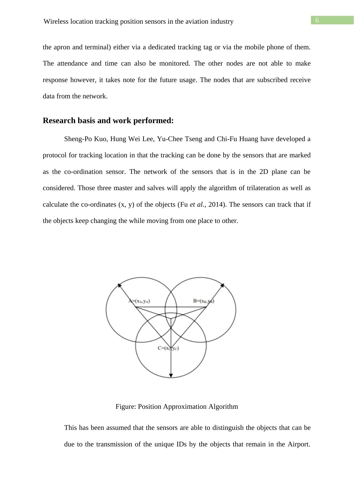
Research basis and work performed:
Sheng-Po Kuo, Hung Wei Lee, Yu-Chee Tseng and Chi-Fu Huang have developed a
protocol for tracking location in that the tracking can be done by the sensors that are marked
as the co-ordination sensor. The network of the sensors that is in the 2D plane can be
considered. Those three master and salves will apply the algorithm of trilateration as well as
calculate the co-ordinates (x, y) of the objects (Fu et al., 2014). The sensors can track that if
the objects keep changing the while moving from one place to other.
Figure: Position Approximation Algorithm
This has been assumed that the sensors are able to distinguish the objects that can be
due to the transmission of the unique IDs by the objects that remain in the Airport.
the apron and terminal) either via a dedicated tracking tag or via the mobile phone of them.
The attendance and time can also be monitored. The other nodes are not able to make
response however, it takes note for the future usage. The nodes that are subscribed receive
data from the network.
Research basis and work performed:
Sheng-Po Kuo, Hung Wei Lee, Yu-Chee Tseng and Chi-Fu Huang have developed a
protocol for tracking location in that the tracking can be done by the sensors that are marked
as the co-ordination sensor. The network of the sensors that is in the 2D plane can be
considered. Those three master and salves will apply the algorithm of trilateration as well as
calculate the co-ordinates (x, y) of the objects (Fu et al., 2014). The sensors can track that if
the objects keep changing the while moving from one place to other.
Figure: Position Approximation Algorithm
This has been assumed that the sensors are able to distinguish the objects that can be
due to the transmission of the unique IDs by the objects that remain in the Airport.
Paraphrase This Document
Need a fresh take? Get an instant paraphrase of this document with our AI Paraphraser
7Wireless location tracking position sensors in the aviation industry
This multiple object is considered by the environment, although these techniques was
depicted for only one of the objects. The sensors are usually having for models of the
operation. the location tracking system in the aviation industry is essential owing to
the advantages it is laced with (Wang et al., 2017). The system can guide and show
the real-time view of the assets location and any such reports can be obtained in a
click away. They are Transmit, Receive, Idle and Sleep on the basis of the operations
that they are performing. Each and every node are having various level of
consumption of power. Hence for minimizing error, an algorithm can be used in that
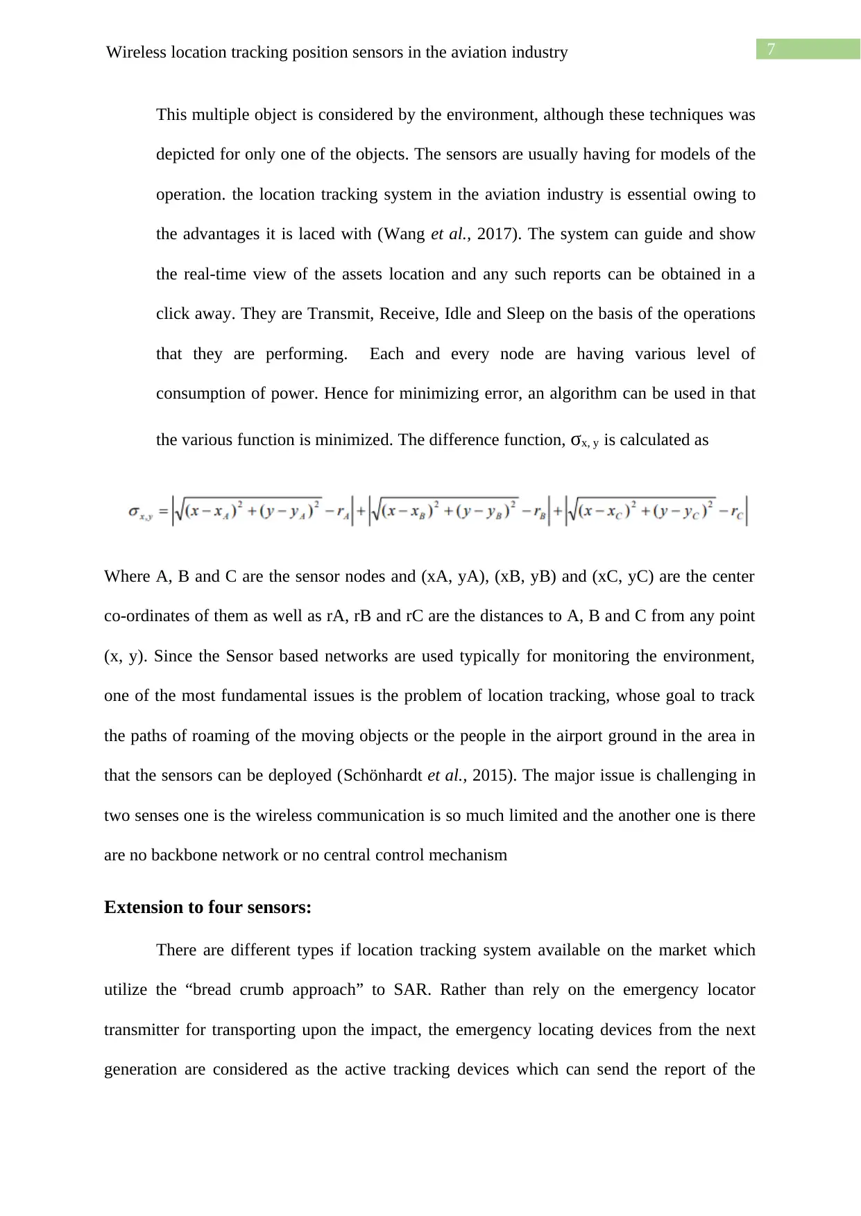
the various function is minimized. The difference function, σx, y is calculated as
Where A, B and C are the sensor nodes and (xA, yA), (xB, yB) and (xC, yC) are the center
co-ordinates of them as well as rA, rB and rC are the distances to A, B and C from any point
(x, y). Since the Sensor based networks are used typically for monitoring the environment,
one of the most fundamental issues is the problem of location tracking, whose goal to track
the paths of roaming of the moving objects or the people in the airport ground in the area in
that the sensors can be deployed (Schönhardt et al., 2015). The major issue is challenging in
two senses one is the wireless communication is so much limited and the another one is there
are no backbone network or no central control mechanism
Extension to four sensors:
There are different types if location tracking system available on the market which
utilize the “bread crumb approach” to SAR. Rather than rely on the emergency locator
transmitter for transporting upon the impact, the emergency locating devices from the next
generation are considered as the active tracking devices which can send the report of the
This multiple object is considered by the environment, although these techniques was
depicted for only one of the objects. The sensors are usually having for models of the
operation. the location tracking system in the aviation industry is essential owing to
the advantages it is laced with (Wang et al., 2017). The system can guide and show
the real-time view of the assets location and any such reports can be obtained in a
click away. They are Transmit, Receive, Idle and Sleep on the basis of the operations
that they are performing. Each and every node are having various level of
consumption of power. Hence for minimizing error, an algorithm can be used in that
the various function is minimized. The difference function, σx, y is calculated as
Where A, B and C are the sensor nodes and (xA, yA), (xB, yB) and (xC, yC) are the center
co-ordinates of them as well as rA, rB and rC are the distances to A, B and C from any point
(x, y). Since the Sensor based networks are used typically for monitoring the environment,
one of the most fundamental issues is the problem of location tracking, whose goal to track
the paths of roaming of the moving objects or the people in the airport ground in the area in
that the sensors can be deployed (Schönhardt et al., 2015). The major issue is challenging in
two senses one is the wireless communication is so much limited and the another one is there
are no backbone network or no central control mechanism
Extension to four sensors:
There are different types if location tracking system available on the market which
utilize the “bread crumb approach” to SAR. Rather than rely on the emergency locator
transmitter for transporting upon the impact, the emergency locating devices from the next
generation are considered as the active tracking devices which can send the report of the
8Wireless location tracking position sensors in the aviation industry
position at an interval of regular time. If the units stop transmit on the impact, the
transmission that are historical can give the last known location of the assets. According to
Villasenor, 2013, Those nodes are able to track the objects as well as relay the information
towards the controlling unit at the time that is required. For different types of operations like
transmission of data, signal processing, communications and gathering of information, the
nodes of the sensors are having a processor, a memory as well as a supporting hardware. The
results for tracking but not show any of the important improvements over the results with the
three sensors. The assumptions are as follows:
1) Sensors can distinguish between multiple objects
2) A hexagonal mesh networks
3) Consider only grid points on the plane
4) Object does not move faster than 5m/s
5) Object moves at a constant speed of uniform distribution between 1~3m/s.
Aviation Applications and Benefits:
Personal Tracking:
According to Scheuner et al., 2016, Locating the staffs all over the airport (both
within on the apron and terminal) either via a dedicated tracking tag or via the mobile phone
of them. The attendance and time can also be monitored.
Asset tracking:
With having thousand numbers of the assets that are including tools, airside vehicles
as well as in terminal assets, a system for real time update of location and management,
enables the staffs for provisioning the major assets throughout the operation in Airport
(Coburn et al., 2018).
⊘ This is a preview!⊘
Do you want full access?
Subscribe today to unlock all pages.
Trusted by 1+ million students worldwide
9Wireless location tracking position sensors in the aviation industry
Improved security:
With a real time, view of the vehicles related to the airside that is including the
location of them, certification of maintenance as well as the other associated information for
the authorisation for the management of the security operation of Airport.
Conclusion:
Thus, it can be concluded from the above report that the sensor based networks are
used typically for monitoring the environment, one of the most fundamental issues is the
problem of location tracking, whose goal to track the paths of roaming of the moving objects
or the people in the airport ground in the area in that the sensors can be deployed. More
researches are needed in this field for enhancing the location tracking system.
Paraphrase This Document
Need a fresh take? Get an instant paraphrase of this document with our AI Paraphraser
10Wireless location tracking position sensors in the aviation industry
References:
Balduzzi, M., Pasta, A. and Wilhoit, K., 2014, December. A security evaluation of AIS
automated identification system. In Proceedings of the 30th annual computer security
applications conference (pp. 436-445). ACM.
Choi, H., Geeves, M., Alsalam, B. and Gonzalez, F., 2016, March. Open source computer-
vision based guidance system for UAVs on-board decision making. In 2016 IEEE Aerospace
Conference (pp. 1-5). IEEE.
Coburn, S., Alden, C.B., Wright, R., Cossel, K., Baumann, E., Truong, G.W., Giorgetta, F.,
Sweeney, C., Newbury, N.R., Prasad, K. and Coddington, I., 2018. Regional trace-gas source
attribution using a field-deployed dual frequency comb spectrometer. Optica, 5(4), pp.320-
327.
Dini, G. and Dalle Mura, M., 2015. Application of augmented reality techniques in through-
life engineering services. Procedia Cirp, 38, pp.14-23.
Fu, C., Carrio, A., Olivares-Mendez, M.A., Suarez-Fernandez, R. and Campoy, P., 2014,
May. Robust real-time vision-based aircraft tracking from unmanned aerial vehicles. In 2014
ieee international conference on robotics and automation (ICRA)(pp. 5441-5446). IEEE.
Georgeson, N.T., Georgeson, G.E. and Troy, J.J., Boeing Co, 2016. Projecting airplane
location specific maintenance history using optical reference points. U.S. Patent 9,448,758.
Gerringer, M.B., Lima, S.L. and DeVault, T.L., 2016. Evaluation of an avian radar system in
a midwestern landscape. Wildlife Society Bulletin, 40(1), pp.150-159.
Heiderscheit, D.D., Rockwell Collins Inc, 2014. Location-based intrusion detection system.
U.S. Patent 8,660,526.

11Wireless location tracking position sensors in the aviation industry
Scheuner, J., Mazlami, G., Schöni, D., Stephan, S., De Carli, A., Bocek, T. and Stiller, B.,
2016, November. Probr-a generic and passive WiFi tracking system. In 2016 IEEE 41st
Conference on Local Computer Networks (LCN) (pp. 495-502). IEEE.
Schönhardt, A., Altube, P., Gerilowski, K., Krautwurst, S., Hartmann, J., Meier, A.C.,
Richter, A. and Burrows, J.P., 2015. A wide field-of-view imaging DOAS instrument for
two-dimensional trace gas mapping from aircraft. Atmospheric Measurement Techniques,
pp.5113-5131.
Strohmeier, M., Lenders, V. and Martinovic, I., 2015, April. Lightweight location verification
in air traffic surveillance networks. In Proceedings of the 1st ACM Workshop on Cyber-
Physical System Security (pp. 49-60). ACM.
Strohmeier, M., Lenders, V. and Martinovic, I., 2015, April. Lightweight location verification
in air traffic surveillance networks. In Proceedings of the 1st ACM Workshop on Cyber-
Physical System Security (pp. 49-60). ACM.
Villasenor, J., 2013. Observations from above: unmanned aircraft systems and privacy. Harv.
JL & Pub. Pol'y, 36, p.457.
Wang, H., Lu, S., Cheng, J. and Zhai, Z.J., 2017. Inverse modeling of indoor instantaneous
airborne contaminant source location with adjoint probability-based method under dynamic
airflow field. Building and Environment, 117, pp.178-190.
Yahav, D., Kranz, Y., Ashkenazi, A., Orenstein, I., Waisman, T. and Abrahami, M., Elbit
Systems Ltd, 2014. Aircraft landing assistance. U.S. Patent 8,687,056.
Yu, X. and Zhang, Y., 2015. Sense and avoid technologies with applications to unmanned
aircraft systems: Review and prospects. Progress in Aerospace Sciences, 74, pp.152-166.
⊘ This is a preview!⊘
Do you want full access?
Subscribe today to unlock all pages.
Trusted by 1+ million students worldwide
1 out of 12
Related Documents


![Evaluating WSN Adoption: A Report on [Company Name]'s Implementation](/_next/image/?url=https%3A%2F%2Fdesklib.com%2Fmedia%2Fimages%2F5c80a5cb7b93434282e3fb9128dc2c36.jpg&w=256&q=75)
Your All-in-One AI-Powered Toolkit for Academic Success.
+13062052269
info@desklib.com
Available 24*7 on WhatsApp / Email
![[object Object]](/_next/static/media/star-bottom.7253800d.svg)
Unlock your academic potential
Copyright © 2020–2026 A2Z Services. All Rights Reserved. Developed and managed by ZUCOL.