Dam Construction Along River Yare Norfolk, UK
VerifiedAdded on 2022/11/25
|14
|4512
|303
AI Summary
This document discusses the construction of a dam along River Yare in Norfolk, UK. It covers the demographic, economic, and social characteristics of Norfolk, as well as site recommendations, site controls and considerations, and the advantages and disadvantages of locating the dam in this location.
Contribute Materials
Your contribution can guide someone’s learning journey. Share your
documents today.
1
Civil Engineering
First Name Last Name
Institution
Civil Engineering
First Name Last Name
Institution
Secure Best Marks with AI Grader
Need help grading? Try our AI Grader for instant feedback on your assignments.
2
Table of Contents
1.0 INTRODUCTION ………………………………………………………………………………………....3
2.0 DEMOGRAPHIC, ECONOMIC, SOCIAL CHARACTERISTICS OF NORFOLK………..………..4
2.1 General…………………………………………………………………………………………………4
2.2 Topography of the area……………………………………………………..….………...…………....5
2.3 Geology.……………………………………………………………………………………...………....5
2.4 Runoff……………………………………………………………………………………...…………...6
2.5 Yield studies……………….………………………………………………………………………..….6
3.0 RECOMMENDATIONS…………………………………………………………………………………...6
4.0 SITE CONTROLS AND CONSIDERATIONS ………………………………………………………….8
5.0 ADVANTAGES AND DISADVANTAGES OF LOCATING THE DAM IN THIS
LOCATION……………………………………………………………………………………………...……...9
6.0 POTENTIAL RISKS………………………………………………………………………….…………...10
CONCLUSION …………………………………………………………………………………….……..…...10
REFERENCES……………………………………………………………………………………….…...……11
3
DAM CONSTRUCTION ALONG RIVER YARE NORFOLK, UK
1. INTRODUCTION
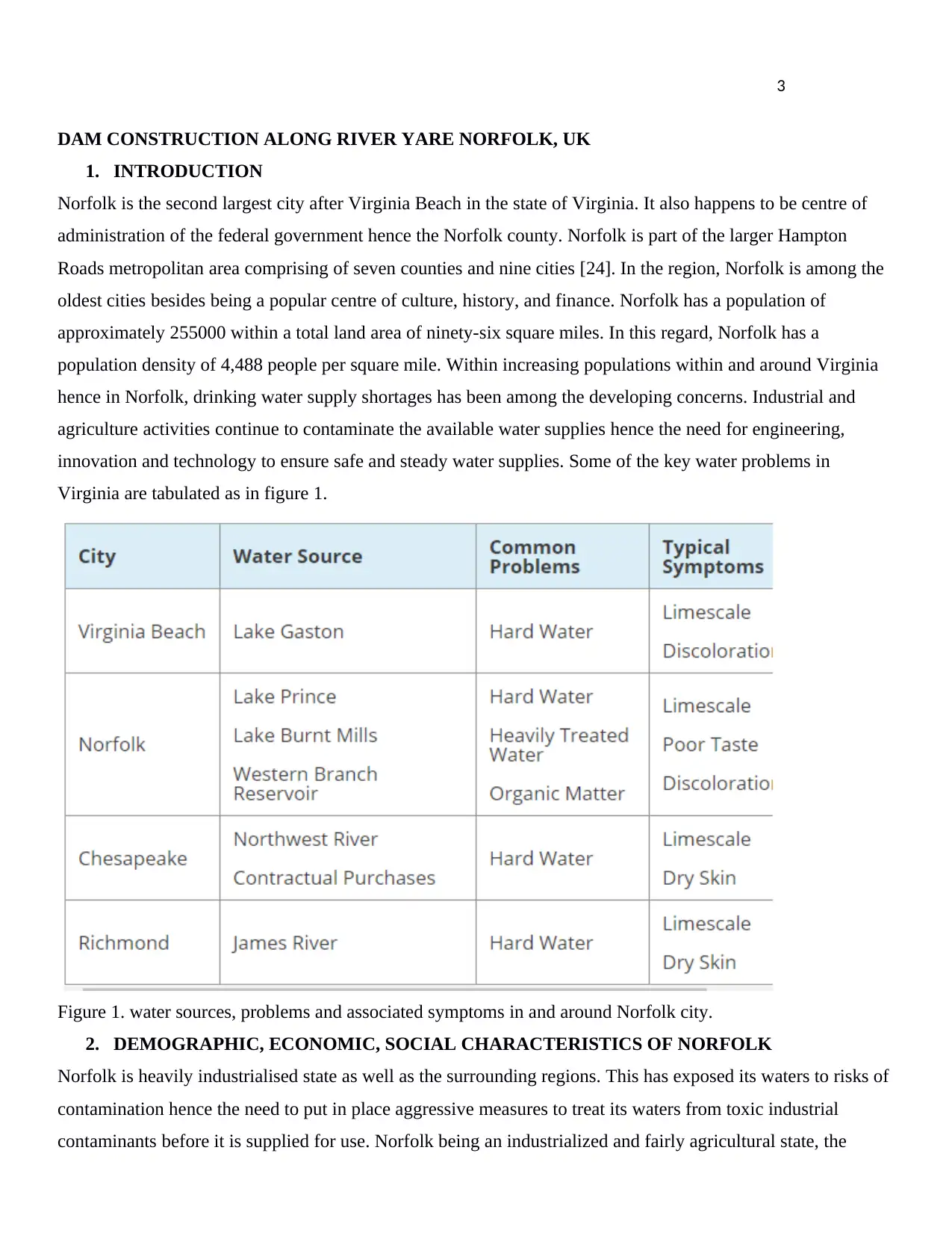
Norfolk is the second largest city after Virginia Beach in the state of Virginia. It also happens to be centre of
administration of the federal government hence the Norfolk county. Norfolk is part of the larger Hampton
Roads metropolitan area comprising of seven counties and nine cities [24]. In the region, Norfolk is among the
oldest cities besides being a popular centre of culture, history, and finance. Norfolk has a population of
approximately 255000 within a total land area of ninety-six square miles. In this regard, Norfolk has a
population density of 4,488 people per square mile. Within increasing populations within and around Virginia
hence in Norfolk, drinking water supply shortages has been among the developing concerns. Industrial and
agriculture activities continue to contaminate the available water supplies hence the need for engineering,
innovation and technology to ensure safe and steady water supplies. Some of the key water problems in
Virginia are tabulated as in figure 1.
Figure 1. water sources, problems and associated symptoms in and around Norfolk city.
2. DEMOGRAPHIC, ECONOMIC, SOCIAL CHARACTERISTICS OF NORFOLK
Norfolk is heavily industrialised state as well as the surrounding regions. This has exposed its waters to risks of
contamination hence the need to put in place aggressive measures to treat its waters from toxic industrial
contaminants before it is supplied for use. Norfolk being an industrialized and fairly agricultural state, the
DAM CONSTRUCTION ALONG RIVER YARE NORFOLK, UK
1. INTRODUCTION
Norfolk is the second largest city after Virginia Beach in the state of Virginia. It also happens to be centre of
administration of the federal government hence the Norfolk county. Norfolk is part of the larger Hampton
Roads metropolitan area comprising of seven counties and nine cities [24]. In the region, Norfolk is among the
oldest cities besides being a popular centre of culture, history, and finance. Norfolk has a population of
approximately 255000 within a total land area of ninety-six square miles. In this regard, Norfolk has a
population density of 4,488 people per square mile. Within increasing populations within and around Virginia
hence in Norfolk, drinking water supply shortages has been among the developing concerns. Industrial and
agriculture activities continue to contaminate the available water supplies hence the need for engineering,
innovation and technology to ensure safe and steady water supplies. Some of the key water problems in
Virginia are tabulated as in figure 1.
Figure 1. water sources, problems and associated symptoms in and around Norfolk city.
2. DEMOGRAPHIC, ECONOMIC, SOCIAL CHARACTERISTICS OF NORFOLK
Norfolk is heavily industrialised state as well as the surrounding regions. This has exposed its waters to risks of
contamination hence the need to put in place aggressive measures to treat its waters from toxic industrial
contaminants before it is supplied for use. Norfolk being an industrialized and fairly agricultural state, the
4
demand for water remains high throughout hence the need to come up with ideas such as dam constructions.
Apart from storing water, dam construction seems a suitable alternative for power generations for use in
industrial and agricultural processes as well as in homes in Norfolk [18]. Additionally, it offers an alternative to
control flood waters and allow for a point treatment and supply systems of treated water.
2.1. General
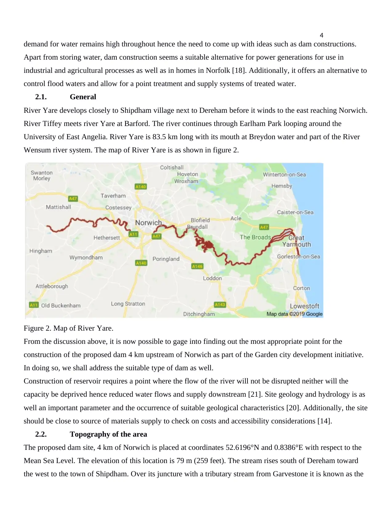
River Yare develops closely to Shipdham village next to Dereham before it winds to the east reaching Norwich.
River Tiffey meets river Yare at Barford. The river continues through Earlham Park looping around the
University of East Angelia. River Yare is 83.5 km long with its mouth at Breydon water and part of the River
Wensum river system. The map of River Yare is as shown in figure 2.
Figure 2. Map of River Yare.
From the discussion above, it is now possible to gage into finding out the most appropriate point for the
construction of the proposed dam 4 km upstream of Norwich as part of the Garden city development initiative.
In doing so, we shall address the suitable type of dam as well.
Construction of reservoir requires a point where the flow of the river will not be disrupted neither will the
capacity be deprived hence reduced water flows and supply downstream [21]. Site geology and hydrology is as
well an important parameter and the occurrence of suitable geological characteristics [20]. Additionally, the site
should be close to source of materials supply to check on costs and accessibility considerations [14].
2.2. Topography of the area
The proposed dam site, 4 km of Norwich is placed at coordinates 52.6196°N and 0.8386°E with respect to the
Mean Sea Level. The elevation of this location is 79 m (259 feet). The stream rises south of Dereham toward
the west to the town of Shipdham. Over its juncture with a tributary stream from Garvestone it is known as the
demand for water remains high throughout hence the need to come up with ideas such as dam constructions.
Apart from storing water, dam construction seems a suitable alternative for power generations for use in
industrial and agricultural processes as well as in homes in Norfolk [18]. Additionally, it offers an alternative to
control flood waters and allow for a point treatment and supply systems of treated water.
2.1. General
River Yare develops closely to Shipdham village next to Dereham before it winds to the east reaching Norwich.
River Tiffey meets river Yare at Barford. The river continues through Earlham Park looping around the
University of East Angelia. River Yare is 83.5 km long with its mouth at Breydon water and part of the River
Wensum river system. The map of River Yare is as shown in figure 2.
Figure 2. Map of River Yare.
From the discussion above, it is now possible to gage into finding out the most appropriate point for the
construction of the proposed dam 4 km upstream of Norwich as part of the Garden city development initiative.
In doing so, we shall address the suitable type of dam as well.
Construction of reservoir requires a point where the flow of the river will not be disrupted neither will the
capacity be deprived hence reduced water flows and supply downstream [21]. Site geology and hydrology is as
well an important parameter and the occurrence of suitable geological characteristics [20]. Additionally, the site
should be close to source of materials supply to check on costs and accessibility considerations [14].
2.2. Topography of the area
The proposed dam site, 4 km of Norwich is placed at coordinates 52.6196°N and 0.8386°E with respect to the
Mean Sea Level. The elevation of this location is 79 m (259 feet). The stream rises south of Dereham toward
the west to the town of Shipdham. Over its juncture with a tributary stream from Garvestone it is known as the
Secure Best Marks with AI Grader
Need help grading? Try our AI Grader for instant feedback on your assignments.
5
Blackwater River. From there it streams in a by and large eastbound bearing passing Barnham Broom and is
joined by the River Tiffey before coming to Bawburgh. It at that point skirts the southern edges of the city of
Norwich, going through Colney, Cringleford, Lakenham and Trowse. At Whitlingham it is joined by the River
Wensum and despite the fact that the Wensum is the bigger and longer of the two, the stream downstream of
their conversion keeps on being known as the Yare [25]. Streaming eastbound into The Broads it passes the
towns of Bramerton, Surlingham, Rockland St. Mary and Cantley. Just before Reedham at Hardley Cross it is
joined by the River Chet. Past Reedham the waterway passes the broadly secluded marshland settlement of
Berney Arms before entering the tidal pool of Breydon Water. Here the Yare is joined by the Rivers Waveney
and Bure lastly enters the North Sea at Gorleston, Great Yarmouth.
2.3. Geology
The development envelops the fluvial, lacustrine and natural stores of the River Yare. It incorporates floodplain
alluvium and a confined advancement of waterway porch stores. The floodplain alluvium involves delicate
muds, residues and fine-grained sands, with groups of peat, overlying fine-to coarse-grained sands and rock.
These rocks are for the most part made out of adjusted stone rocks and cobbles, with a little chalk, seldom
shelly yet normally silty. The rock generally happens in covered channels overlain by the Breydon Formation.
Waterway patio stores are to a great extent rock and sand [11]. The rock is commanded by subangular to
adjusted stone, including huge cobbles, with certain rocks of quartz and quartzite. Gravelly silt having a place
with this development have been recorded in boreholes seaward.
2.4. Runoff
The likelihood of river flood hazard in this area has been diminished by the usage of flood guards. At present
20 properties inside this sub-region are in danger from the 1% yearly likelihood waterway flood. There is a
little measure of chiefly grade four agrarian land in danger in the 1% yearly likelihood river flood, however
there is no basic framework in danger [10]. Notwithstanding, as Norwich is exceedingly urbanized with critical
improvement behind the protections, if the safeguards here were to fizzle the results could be significant.
2.5. Yield studies
Catchment region contributing up to the Brundall measure station is 35.3 Sq km. Yield studies have been
completed from the spill over information accessible at Brundall station. Examination was done for accessible
30 years recorded information from 1976 to 2004 to arrive yearly reliable streams. 100%, 95% and 75%
trustworthy yearly yield are worked out as 216 MCM, 220 MCM and 274MCM at check release station.
Proposed dam site is found upstream of the Brundall check release station. The proportionate 100%, 95% and
75% yearly reliable yield at dam site are 240MCM, 243MCM and 261MCM individually [13].
6
3. SITE RECOMMENDATIONS
The chosen site for capacity supply needs to encourage required capacity dependably and to securely take up
the development without causing more prominent natural difficulties and including insignificant migration and
restoration of the surrounding population/ communities. Water assets improvement ventures are intended to
play out specific capacities and to serve a specific region [15]. Three significant objectives in choosing the dam
locales are:
The site must be sufficiently satisfactory to help the dam and its appurtenant structures.
The territory for a supply dam should be in a straight and thin stream reach with adequate region on
upstream to hold the intended storage capacity [40].
The dam foundation ought to be moderately free of major faults and shears [16].
By careful studies and understanding of the flow of River Yare as well as factors such as topography, geology,
runoff, and yield studies, I recommend that the dam construction site is located at Norton Subcourse area
proximate to HH46+M7 Reedham. The coordinates of the proposed site are 52°33'24.2"N and 1°33'38.4"E
(52.556717, 1.560669). the yield of River Yare at this location is adequate to supply sufficient storage. It is
observable that no significant benefits would arise if alternative sites either upstream or downstream of this
location is adopted. This section achieves a relatively fixed alignment based on the most recent survey data.
Such a section provides an economical section for a gravity structure as reservoir as the good foundation grade
rock occurs exists from shallow depths [2].
The geology and catchment properties of the waterway will give quantitative data with respect to the
accessibility of water ([9]. This parameter will have impact on the dam type and plan the sort of dam and has
linkages with the ground profile/geology. In the event that river valley is restricted, a gravity dam is suitable
[8]. The accessibility of development materials and cost of the dam impacts the kind of dam. As the
impenetrable hearting material isn't accessible in the region of the proposed dam site, arrangement of concrete
core with concrete faced slab is imperative. The forces considered for the dam include; Self load of dam,
Horizontal water weight, weight of water on upstream slanted face of the dam, Uplift force at the base of the
dam area, Wave weight, wind loads etc.
Looking in to the useful viewpoints, Rock fill dam isn't appropriate for this area consequently the equivalent
isn't considered. The proposed dam area and arrangement has been fixed dependent on the most recent review
information which would give affordable segment of the gravity structure as the great establishment grade rock
along the arrangement is available at shallow profundity with great level of core retrieval. The site is situated in
overwhelming precipitation zone and such a site roller compacted concrete gravity dam is generally
appropriate. A standout amongst the most amazing parts of Roller Compacted Concrete (RCC) dams have been
7
their capacity to be structured and built quickly just as financially [2]. The Roller Compacted Concrete dam
innovation depends on very motorized exercises of transporting Roller Compacted Concrete to the placement;
it's spreading and compacting as a slenderer development process [27]. One of the keys to a quick financial and
quality Roller Compacted Concrete dams is basic dam structure which requires the minimization of
obstructions to the Roller Compacted Concrete procedures of the dam by which the contractor would most
likely build the dam in a faster way continuously. Roller Compacted Concrete development arrangements and
their planning assume a huge job for the persistent development advance especially amid wet seasons. In
Construction of Roller Compacted Concrete dam's river redirection issues can be taken care of easily as after
the underlying part is developed, the spillages of water amid regular blaze floods can be allowed without
making arrangements for any additional preoccupation [37]. The type of the proposed dam therefore will be a
Roller Compacted Concrete Gravity Dam. The dam could be used to store water for irrigation as well as
generate hydroelectric power hence additionally achieving favourable cost benefit analysis of the project when
completed [3].
4. SITE CONTROLS AND CONSIDERATIONS
On the upstream, the river will have to be diverted through tunnels or by construction of a cofferdam to control
water flows to allow for the construction to take place. Essentially, the construction of the dam at the proposed
site will entail 6 steps [38]. The steps include;
i. River diversion
ii. Foundation preparation at the site
iii. Building of the dam
iv. Filling the built reservoir by releasing the controls or cofferdam
v. Valves and flood gates tested
vi. Monitoring of the built Reinforced Compacted Concrete Gravity Dam.
Before development work in a river channel can be commenced, it is required that the river be redirected or
diverted. In two-Stages construction, the watercourse is engaged to alternative side of the canal by a cofferdam
whereas construction stays on another side [34]. When the construction finishes, the watercourse is filled over
outlets in this section or may even be permitted to over top the complete bit as construction progresses on the
other channel section. In the event that geologic and topographic settings are satisfactory, a passageway or re-
routing canal might be employed to permit the river water around the dam site [28]. A passageway is
particularly gainful as it certainly commits valuable need after fruition of the dam. For instance, four 50 feet
round cement lined passages were utilized for redirection at Hoover Dam and later changed over to outlet
works [4].
Paraphrase This Document
Need a fresh take? Get an instant paraphrase of this document with our AI Paraphraser
8
A redirection channel or route have to be fortified for passing on a torrent preferred by recurrence examination
as a serviceable risk in view on the risks on each precise action. It is beneficial to design construction of the
lower part of a dam within typical low-stream phases to avoid the preoccupation problem. The formation must
be dug up to sturdy rock before any concrete is discharged [17]. After uncovering, cavities or fault planes in the
fundamental strata are fixed with cement or grout. Frequently a grout blind is set close to the impact point of
the dam to lessen drainage [29].
A bond mortar and water are now and then intermingled with a slight portion of fine totals (sand) is controlled
under strain into the openings penetrated into the stones. Grouting at bulks up to about forty psi might be
conducted before cement is set for the dam, however high-weight cementing (200 psi) is done from changeless
demonstrations in the dam after the dam is done with the goal that the solidity of the dam can compete against
the mortaring weights [7].
Concrete for the dam is normally set in squares relying upon the components of the dam, with a most extreme
width of around 50 ft on enormous dams ("Selection of tailings impoundment sites - RGC"). The most extreme
stature of a solitary pour is for the most part around 5 ft. Segments are poured on the other hand with the goal
that each square is allowed to stand a few days before another is poured by it or over it. After individual
segments are poured, they are sprinkled with water and generally shielded from the drying impact of the air
[23].
After the structure work is expelled, the horizontal surfaces of each area are painted with a paint (asphaltic
emulsion) to avoid adherence to bordering segments and to frame development joints to lessen breaking of the
solid [5]. Keyways are given between segments to convey the shear forces from one area to the contiguous one
and make the gravity dam go about as a solid structure. Metal water stops are likewise put in the vertical
development joints close to the upstream face to counteract spillage [6]. Review displays to allow access to the
inside of the dam are framed as the solid is set. These exhibitions might be essential for grouting task, for
activity and upkeep of entryways and valves, and as capturing channels for water which saturates the gravity
dam [31]. This will ensure that he dam is safely built.
5. ADVANTAGES AND DISADVANTAGES OF LOCATING THE DAM IN THIS LOCATION
The chosen location has a set of advantages or favourable conditions for the location of the dam. Firstly, it
would provide for an alternative of hydroelectric power generation which will be beneficial to surrounding
farms and factories as well for residential use [35]. Secondly, it would provide storage of water for agricultural
use hence support irrigation farming around the area. Thirdly, the reservoir construction ensures safety from
flooding due excess precipitations [39]. Also, location of the dam at this point would promote recreational
activities and enhance navigation across river Yare.
9
Nevertheless, locating the dam in this site has also a set of disadvantages. Firstly, dams accumulate eroded
sediments from upstream [36]. When that happens, the downstream areas are deprived of such sediments and
specifically nutrient supply [22]. Through sedimentation, the river loads from erosion are reduced, this
increases ease and hence speed of flow downstream. The resulting aggressive flow result in erosion of lands as
it flows downstream. This commonly the case of river rejuvenation. Also, extinctions of species in the water
ecosystems is enhanced as the lifecycles of species such as fish and other organisms is affected when they are
caused to pass through or be retained in the created reservoir [26]. Lastly, failure of this dam could be
catastrophic considering the amount of damage that would result from flooding, both property and human life
[19].
6. POTENTIAL RISKS
Some of the potential risks in building the dam include; fragmentation of habitat, loss of land cover, changes in
aquatic ecosystems, destruction of natural landscape, loss of biodiversity, pollution of habitat from cofferdam
and tunnel construction [32]. Also, risks such as wastewater, noise pollution, bioaccumulation of heavy metals
could result from use of machinery such as explosives and diesel/oil operated machinery [33].
CONCLUSION
Identifying a suitable location of a dam is crucial undertaking and has significant bearing on the environment.
When accomplished, it brings with significant share of advantages but a number of disadvantages may as well
arise. Well thought and properly environmentally scrutinized feasibility studies is important to understand the
site characteristics as well as the capacity of the river from which the dam is to be created. Poor choice of the
site could render construction of the dam expensive, impractical or generally unbeneficial to the surrounding
community. With much emphasis of such consideration, the selection of the proposed site at coordinates
52°33'24.2"N and 1°33'38.4"E along River Yare is undeniably feasible.
10
REFERENCES
[1] Chapter 1. Considerations in the Selection of Sites for Aquaculture, 05-Jul-
2017. [Online]. Available: http://www.fao.org/3/x5744e/x5744e02.htm.
[Accessed: 17-May-2019].
[2] “A methodology for the pre-selection of suitable sites for surface and
underground small dams in arid areas: A case study in the region of Kidal, Mali,”
Physics and Chemistry of the Earth, Parts A/B/C, 22-May-2007. [Online].
Available:
https://www.sciencedirect.com/science/article/pii/S1474706507000770.
[Accessed: 17-May-2019].
[3] M. Alembagheri and M. Ghaemian, “Seismic assessment of concrete gravity
dams using capacity estimation and damage indexes,” Earthquake Engineering
& Structural Dynamics, vol. 42, no. 1, pp. 123–144, 2012.
[4] A. F. Arrigo, Imaging Hoover Dam: the Making of a Cultural Icon. Reno, NV:
University of Nevada Press, 2014.
[5] Z. Bofang, “Thermal Stresses in Concrete Gravity Dams,” Thermal Stresses
and Temperature Control of Mass Concrete, pp. 267–285, 2014.
[6] Cameron, Yare, River. [Online]. Available:
http://literarynorfolk.co.uk/yare,_river.htm. [Accessed: 17-May-2019].
[7] “dam design,” Dictionary Geotechnical Engineering/Wörterbuch GeoTechnik,
pp. 333–333, 2014.
Secure Best Marks with AI Grader
Need help grading? Try our AI Grader for instant feedback on your assignments.
11
[8] “factors affecting selection of dam,” Engineering Articles, 15-May-2015.
[Online]. Available: http://www.engineeringarticles.org/factors-affecting-the-
selection-of-a-particular-type-of-dam/. [Accessed: 17-May-2019].
[9] “Factors Affecting the Location of Dam of Hydroelectric ...,” 2017. [Online].
Available: https://www.brighthubengineering.com/power-plants/9263-factors-
affecting-the-location-of-hydroelectric-power-plant-dams/. [Accessed: 17-May-
2019].
[10] C. A. Fetzer, W. F. Swiger, and R. W. Kramer, “Earthfill Dam Construction
and Foundation Treatment,” Advanced Dam Engineering for Design,
Construction, and Rehabilitation, pp. 321–353, Jul. 2014.
[11] S. Fletcher and C. Carpenter, Elephant Butte Dam. Charleston, SC: Arcadia
Publishing, 2015.
[12] “Fuzzy modelling for selection of most suitable location for a dam,” Fuzzy
modelling for selection of most suitable location for a dam | International Journal
of Recent Scientific Research, 2018. [Online]. Available:
http://www.recentscientific.com/fuzzy-modelling-selection-most-suitable-location-
dam. [Accessed: 17-May-2019].
[13] “GENERAL GUIDELINES FOR NEW DAMS AND IMPROVEMENTS TO ...,” 2015.
[Online]. Available: https://www.in.gov/dnr/water/files/wa-damguidelines.pdf.
[Accessed: 17-May-2019].
[14] A. Goldin and L. N. Rasskazov, “Dam design using earth materials,” Design
of Earth Dams, pp. 240–298, 2017.
[15] M. Graf, Dams. South Yarra, Victoria: Macmillan Education, 2018.
12
[16] “Gravity dams on rock foundations,” Dams and Appurtenant Hydraulic
Structures, 2nd edition, pp. 521–571, 2014.
[17] “Gravity dams on soil foundations,” Dams and Appurtenant Hydraulic
Structures, 2nd edition, pp. 573–595, 2014.
[18] “Hamlet (adapt. Norfolk),” Hamlet, 2016.
[19] M. A. Hariri-Ardebili and V. Saouma, “Quantitative failure metric for gravity
dams,” Earthquake Engineering & Structural Dynamics, vol. 44, no. 3, pp. 461–
480, 2014.
[20] “IDENTIFICATION OF SUITABLE DAM SITE: A SURVEY,” 2016. [Online].
Available:
http://www.iaeme.com/MasterAdmin/uploadfolder/IJCET_07_05_007/IJCET_07_05_
007.pdf. [Accessed: 17-May-2019].
[21] J. Khatiwada, “Dam and types of dam with site selection,” LinkedIn
SlideShare, 03-Apr-2017. [Online]. Available:
https://www.slideshare.net/JyotiKhatiwada1/dam-and-types-of-dam-with-site-
selection. [Accessed: 17-May-2019].
[22] C. Kutzner, “Assessment of the performance of dams,” Earth and Rockfill
Dams, pp. 91–104, 2018.
[23] A. O. Lawrence, “A Geophysical Approach to Post-Construction Integrity
Assessment of Earth Dam Embankment, Case Study of Ero Dam, Ikun- Ekiti
Southwest Nigeria,” SDRP Journal of Earth Sciences & Environmental Studies, vol.
1, no. 3, 2017.
13
[24] Rapidan Dam: the construction of a landmark. Mankato, MN: Blue Earth
County Historical Society, 2010.
[25] “River Yare,” NUAC. [Online]. Available: http://nuac.org.uk/waters/yare.html.
[Accessed: 17-May-2019].
[26] S. C. Rodrigues and T. I. Silva, “Dam Construction And Loss Of Geodiversity
In The Araguari River Basin, Brazil,” Land Degradation & Development, vol. 23,
no. 4, pp. 419–426, 2012.
[27] “Roller-compacted concrete gravity dams,” Dams and Appurtenant
Hydraulic Structures, 2nd edition, pp. 597–668, 2014.
[28] S. Rout, T. Sahoo, and S. Das, “Design of tailing dam using red mud,” Open
Engineering, vol. 3, no. 2, 2013.
[29] “Selection of Dam Site,” Engineering Articles, 22-May-2015. [Online].
Available: http://www.engineeringarticles.org/selection-of-dam-site/. [Accessed:
17-May-2019].
[30] “Selection of tailings impoundment sites - RGC.” [Online]. Available:
https://www.rgc.ca/files/publications/tailings.pdf. [Accessed: 17-May-2019].
[31] J. D. Silva, “Optimization of concrete gravity dams foundation drainage
systems,” Dams and Reservoirs, Societies and Environment in the 21st Century,
Two Volume Set, pp. 633–639, 2006.
[32] V. B. Sudakov, “Ecological aspects of modern technologies in dam
construction,” Hydrotechnical Construction, vol. 28, no. 11, pp. 635–636, Apr.
2013.
Paraphrase This Document
Need a fresh take? Get an instant paraphrase of this document with our AI Paraphraser
14
[33] H. Takahashi and M. Yakata, “Risk Sharing On Dam Construction Projects,”
Journal of Construction Management, JSCE, vol. 9, pp. 19–28, 2012.
[34] Tandon, “Structural Geology II,” LinkedIn SlideShare, 24-Sep-2013. [Online].
Available: https://www.slideshare.net/gauravhtandon1/structural-geology-ii-
26485320. [Accessed: 17-May-2019].
[35] To reinstate and extend the deadline for commencement of construction of
a hydroelectric project involving Jennings Randolph Dam: report (to accompany
H.R. 2122). Washington, D.C.: U.S. Government Publishing Office, 2017.
[36] H. Tosun, Dam engineering. London: IntechOpen, 2019.
[37] J. Walewski and H. Sadatsafavi, “Megaproject Success: Hoover Dam
Construction and Pre-Construction Management Ingenuity,” Hoover Dam, 2010.
[38] P. Wang, S. Dong, and J. P. Lassoie, “A Global Review of Large Dam
Construction,” The Large Dam Dilemma, pp. 1–23, 2013.
[39] M. Wieland, Proceedings of the 3rd International Conference on Dam
Engineering, 20-22 March 2002, Singapore. Singapore: CI-Premier Pte Ltd, 2002.
[40] Y. Yare and G. K. Venayagamoorthy, “Real-time transient stability
assessment of a power system during energy generation shortfall,” 2010
Innovative Smart Grid Technologies (ISGT), 2010.
1 out of 14

Your All-in-One AI-Powered Toolkit for Academic Success.
+13062052269
info@desklib.com
Available 24*7 on WhatsApp / Email
![[object Object]](/_next/static/media/star-bottom.7253800d.svg)
Unlock your academic potential
© 2024 | Zucol Services PVT LTD | All rights reserved.