Understanding GIS and its Applications
VerifiedAdded on 2023/01/19
|14
|3900
|53
AI Summary
This document provides an introduction to Geographic Information System (GIS) and its applications. It explains the concept of GIS, its role in research and analysis, and its use for visualization, analysis, and decision making. The document also discusses the importance of precision and accuracy in GIS and explores the process of georeferencing and geocoding. It includes a practical example of using QGIS for digitizing and georeferencing maps.
Contribute Materials
Your contribution can guide someone’s learning journey. Share your
documents today.

Dell
Business Intelligence
Business Intelligence
Secure Best Marks with AI Grader
Need help grading? Try our AI Grader for instant feedback on your assignments.

Contents
Introduction.........................................................................................................................................2
Part a)...................................................................................................................................................2
Part b)...................................................................................................................................................3
Part c)...................................................................................................................................................3
Part d)...................................................................................................................................................4
Part f)....................................................................................................................................................8
Part g)...................................................................................................................................................9
Conclusion..........................................................................................................................................10
Introduction
We shall be using Data and Information as provided to us and based in Sri Lanka, with file
types like “comma separated files” (.csv), “shape files” (.shp) and raster files (.asc) for this
exercise and apply specific methodologies, procedures and instruments from the GIS module.
These are based on Vector and Raster models. We shall evaluate, understand and study
various topics by applying the above tools and same time will conduct visual display as
advised, relevant to the GIS format (Google Earth, PostgreSQL, Quantum Geographic
Information System) and applicable for our task.
Part a)
We shall now try to understand the concept of GIS and how it is relevant and useful in lot of
research and analytical work. First question, what is GIS? Now GIS stands for“Geographic
Information System”, and it basically means"a computer system capable of holding and
using data describing places on the earth's surface." In actuality, GIS encompasses more than
just a computer system, a program that evaluates, saves, manipulates and visualizes
geographic information, usually in a map.A geographic information system (GIS) lets us
visualize, question, analyse, and interpret data to understand relationships, patterns, and
trends.
GIS application isa tool that performs spatial query, analysis, edit spatial data and create hard
copy maps. In simple way GIS can be defined as an image that is referenced to the earth, has
two co-ordinated and these data is stored on the system. Thesecoordinates can be projected
on Vector or Raster models for display and end use e.q Maps, Charts etc. The system will
consist of various layers of information which can be edited, joined, merged with other
contents, designed, location based data/information, user based modules etc.
GIS can be used as tool in both problem solving and decision making processes, as well as
for visualization of data in a spatial environment. Geospatial data can be analysed to
determine the location of features and relationships to other features in the area. It uses
various branches of engineering, software, technologies which come together to give the user
the final finished product. Its application can be found in various sectors like
Telecommunication, Mapping, Road safety Analysis, Transport and Logistics, Surveying,
Geological Usage, etc. Much of is practical use is carried out by Mobile/ Tele-companies and
position based services.
We now shall point out the two important parameters related to the GIS tool. “Precision” and
“Accuracy”. Accuracy is the degree of veracity while precision is the degree of
reproducibility.
Accuracy can be defined as the degree or closeness to which the data on a map matches with
its real world values.i.e. in relation to GIS, it will mean the accuracy in the values of height,
distance, altitude etc, and the level of errors in this information. When considering
information on a map or digital dataset, the definition of accuracy is complicated by the
perception, conceptualization and representation of reality. As such, in GIS the wider
understanding of accuracy must consider all aspects of accuracy including its position;
temporal aspects; thematic aspects and completeness
While accuracy refers only to how close the measurement is to the true value, is Precision
related to resolution and variation. This is to say, how much data is shown over a given area.
In a way this is a measure of the spatial generalization of the data.In vector data, this may be
considered a function of the scalability and preference of the data capture and cartographer
based on the purpose of data. With raster data, the resolution is usually understood to be the
grid size of the data, with the value representing the thematic information of interest. In
terrain models these values can represent elevations at the top of features, such as in a digital
surface model (DSM), and values on the bare earth or digital terrain model (DTM).
Usage and type of tools used will decide as to what will be the level of accuracy required for
the GIS. Also, more precision required in information will cost more and also will be difficult
to obtain.
Part b)
When co-ordinates of spatial dates are referenced to their corresponding positions on
the surface of earth then it is called “Georeferencing” of spatial data.Consistency,
completeness, and reliability of referenced spatial information are simultaneously
improved. Georeferencing is to establish a relationship between images and object coordinate
systems. It is crucial to make satellite and aerial as well as terrestrial imagery useful for
mapping.Georeferencing is crucial to making aerial and satellite imagery, usually raster
images, useful for mapping as it explains how other data, such as the above GPS points,
relate to the imagery. Very essential information may be contained in data or images that
were produced at a different point of time. It involves co-ordinates of spatial dates being
referenced to their corresponding positions on the surface of earth. Here data is registered
Secure Best Marks with AI Grader
Need help grading? Try our AI Grader for instant feedback on your assignments.
with a co-ordinate system that is related to the earth’s surface that means a relationship is
established between (x, y) co-ordinate on the map or on the computer screen and its
corresponding latitude, longitude co-ordinate on earth’s surface. It visualises the relevant
address of a given map or location, analyses and then displays that information.
Next we come to the term “Geocoding”, which is the process of converting an
address into spatial data and associating the exact geographical coordinates for that address. It
is used in geographical information systems to help find the coordinates of a place or address.
Geocoding can be done simply through address interpolation, which uses data from a
street GIS where the street network is already inputted within the geographic coordinate
space. Attributed in each street segment are address ranges, such as house numbers from one
segment to another. Here is what geocoding does: (1) It takes an address, (2) matches it to a
street and particular segment (e.g. a block), and (3) interpolates the address position. Used
widely everywhere for preparing charts and maps for various locations and areas. Can be also
used for analysing a set of parameters, in a given area and search for people of a particular
profession etc.
Open QGIS (on a Windows computer you will probably have many options within the
QGIS Start Menu folder – choose the ‘QGIS Desktop’ option – not ‘QGIS Browser’ or
‘GRASS’)
Create a new Project file in QGIS framework and then save it to a particular location
or else it will be saved at its default location. This can be confirmed in the setting section
through the Menu / Properties. As per the type and size of the Data which will be used for the
project, set up the “Coordinate Reference System (CRS)” and the corresponding area that
has to be mapped. Go to the menu Project>Project Properties and select the ‘CRS’ tab at the
side. First select ‘Enable on the fly CRS transformation’ at the top of this window then use
the filter box to find and select OSGB 1936 / the British National Grid with the authority ID
ESPG:27700 from under the projected coordinate systems heading.
Part c)
Starting “ArcGIS”
“ArcGIS” is a platform for organizations to create, manage, share, and analyse
spatial data. It consists of server components, mobile and desktop applications, and developer
tools.If your computer has ArcGIS 10.1 already installed, you will notice that there are
several components to the software itself. The most important component of the software,
and the one you will be using in this tutorial is ArcMap 10.1. Once ArcMap is open you
should see the ArcMap - Getting Started dialogue box (Eom, 2014).
We shall see as to how to go about making an “ArcGIS”.
To begin making a map click OK, and the Dialogue box will disappear, leaving you a blank
map.
Getting Data
Under the Administrative and Political Boundaries section found on the left side of
the page below State-wide Data, click on the forth file from the top, County.
Under Infrastructure click on the first file, rainfall. This file shows all climate details.
Adding Data to ArcMap
Now is finally time to see your data be put into ArcMap. In order to do this, you will
have to have both the downloaded data folders and ArcMap open at the same time. There will
be three main files you will be dragging from the downloaded data folders and dropping into
Arc Map.
Part d)
We shall now take an example to understand the practical use of QGIS. Let us take a
forest/jungle region that has to be updated with the region’s data. Now the data that is already
collected may be very old, like years or even decades old. It may have been collected with
old methods and technics that might not be relevant today. All these data and information will
be used in the QGIS platform and analysed. So the first step will be to collect all this data and
digitize the information on the system. To digitize these data, the first basic step will be to
scan all the information and georeference it to a paper map of the specified area (Harder and
Göde, 2012).
The steps involved in the process will include,
Open QGIS and set the project’s CRS to ETRS89 / ETRS-TM35FIN in Project ‣
Project Properties CRS, which is the currently used CRS in Finland. Make sure that‣ Enable
‘on the fly’ CRS transformation is checked, since we will be working with old data that is
another CRS.
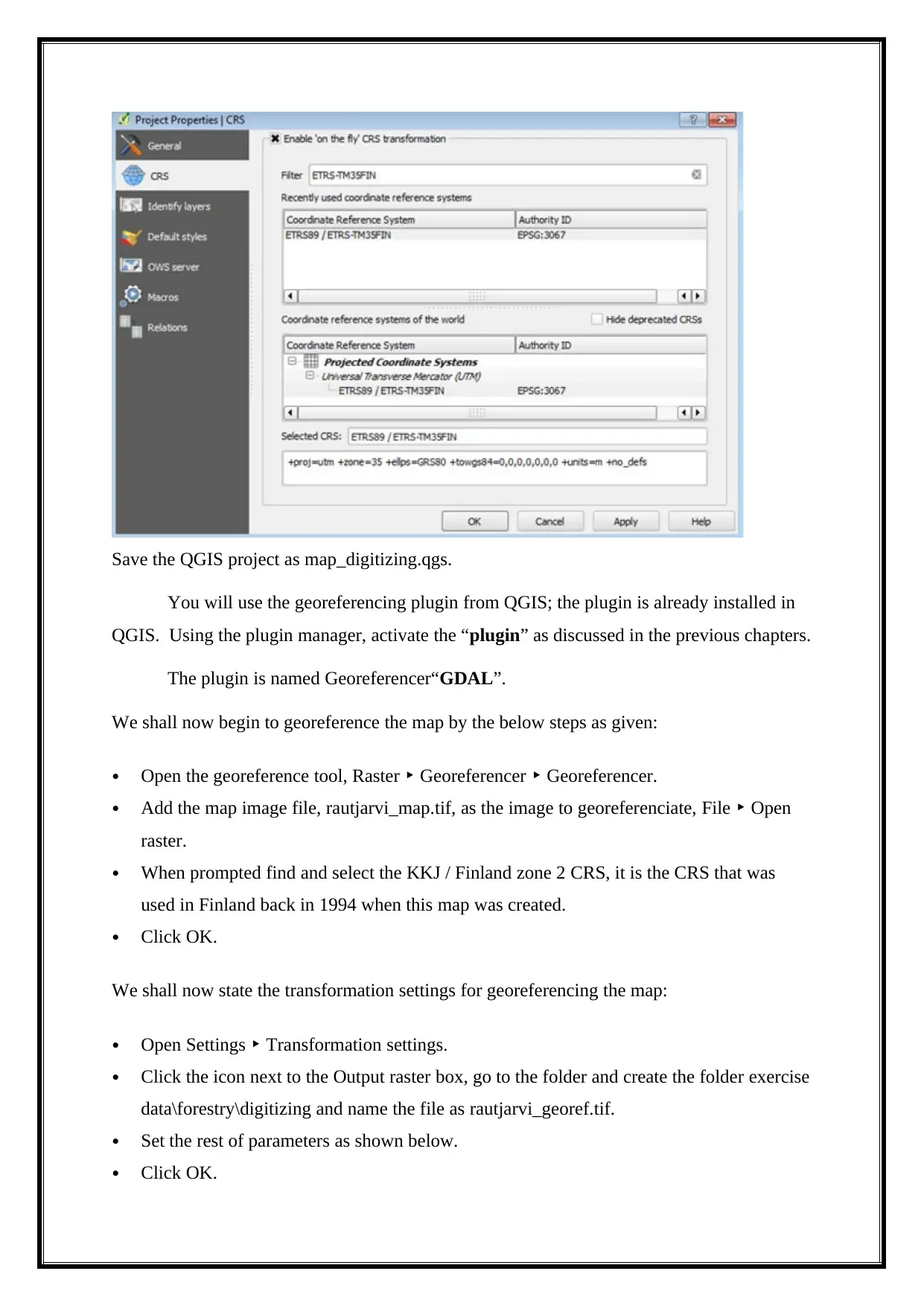
Save the QGIS project as map_digitizing.qgs.
You will use the georeferencing plugin from QGIS; the plugin is already installed in
QGIS. Using the plugin manager, activate the “plugin” as discussed in the previous chapters.
The plugin is named Georeferencer“GDAL”.
We shall now begin to georeference the map by the below steps as given:
Open the georeference tool, Raster Georeferencer Georeferencer.‣ ‣
Add the map image file, rautjarvi_map.tif, as the image to georeferenciate, File Open‣
raster.
When prompted find and select the KKJ / Finland zone 2 CRS, it is the CRS that was
used in Finland back in 1994 when this map was created.
Click OK.
We shall now state the transformation settings for georeferencing the map:
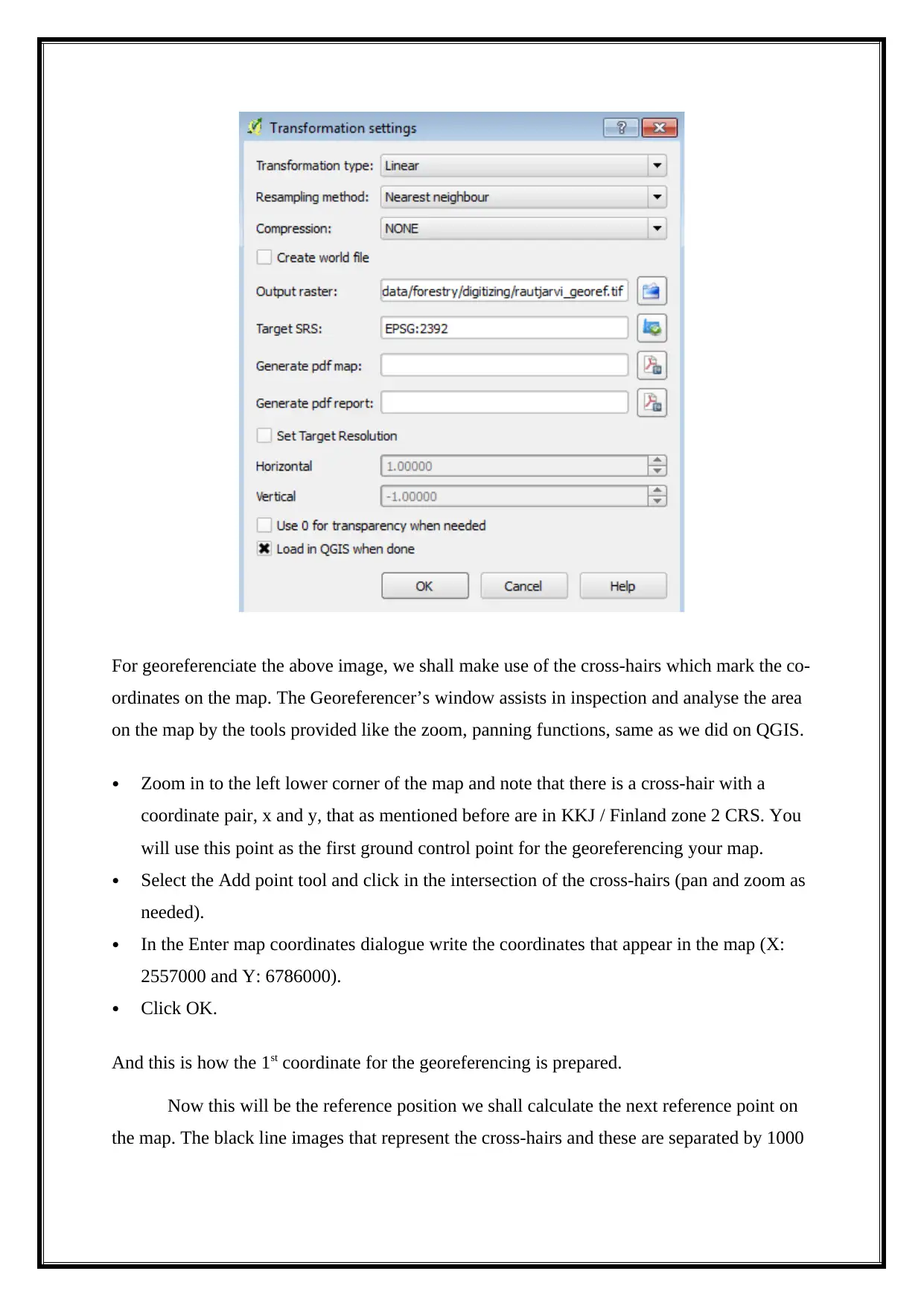
Open Settings Transformation settings.‣
Click the icon next to the Output raster box, go to the folder and create the folder exercise
data\forestry\digitizing and name the file as rautjarvi_georef.tif.
Set the rest of parameters as shown below.
Click OK.
Paraphrase This Document
Need a fresh take? Get an instant paraphrase of this document with our AI Paraphraser
For georeferenciate the above image, we shall make use of the cross-hairs which mark the co-
ordinates on the map. The Georeferencer’s window assists in inspection and analyse the area
on the map by the tools provided like the zoom, panning functions, same as we did on QGIS.
Zoom in to the left lower corner of the map and note that there is a cross-hair with a
coordinate pair, x and y, that as mentioned before are in KKJ / Finland zone 2 CRS. You
will use this point as the first ground control point for the georeferencing your map.
Select the Add point tool and click in the intersection of the cross-hairs (pan and zoom as
needed).
In the Enter map coordinates dialogue write the coordinates that appear in the map (X:
2557000 and Y: 6786000).
Click OK.
And this is how the 1st coordinate for the georeferencing is prepared.
Now this will be the reference position we shall calculate the next reference point on
the map. The black line images that represent the cross-hairs and these are separated by 1000
meters from each other both in North and East direction. Calculate the coordinates of those
points in relation to the first one.
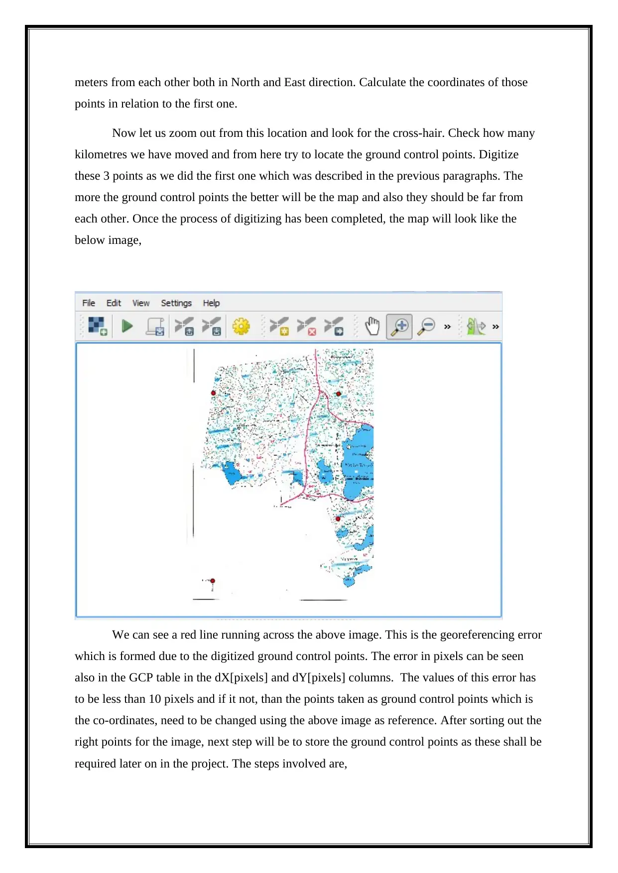
Now let us zoom out from this location and look for the cross-hair. Check how many
kilometres we have moved and from here try to locate the ground control points. Digitize
these 3 points as we did the first one which was described in the previous paragraphs. The
more the ground control points the better will be the map and also they should be far from
each other. Once the process of digitizing has been completed, the map will look like the
below image,
We can see a red line running across the above image. This is the georeferencing error
which is formed due to the digitized ground control points. The error in pixels can be seen
also in the GCP table in the dX[pixels] and dY[pixels] columns. The values of this error has
to be less than 10 pixels and if it not, than the points taken as ground control points which is
the co-ordinates, need to be changed using the above image as reference. After sorting out the
right points for the image, next step will be to store the ground control points as these shall be
required later on in the project. The steps involved are,
File Save GCP points as....‣
In the folder exercise_data\forestry\digitizing, name the file rautjarvi_map.tif.points.
Finally, georeference you map:
File Start georeferencing.‣
Note that you named the file already as rautjarvi_georef.tif when you edited the
Georeferencer settings.
Now you can see the map in QGIS project as a georeferenced raster. Note that the raster
seems to be slightly rotated, but that is simply because the data is KKJ / Finland zone 2 and
your project is in ETRS89 / ETRS-TM35FIN.
Part e)
Mapping Categorical Data
Use of various colour tools for specific data description and for simple data which
cannot be in numerical category is described in this section. Categorical variables are also
known as discrete or qualitative variables. Categorical variables can be further categorized as
nominal, ordinal or dichotomous. Let us consider an example for a beach and a wetland. The
category of a beach could not be described as two times the value of a wetland; it is different
in kind rather than amount. This categorical data is displayed on the chart as a shape, colour,
shaded portion, or a colour hue.Quantitative data can also be effectively portrayed using
symbol variations such as orientation and pattern spacing, but hue, shape, lightness, and size
are most often used because they are the most easily and correctly understood symbols.The
CrimeViz map application (CrimeViz) developed in the GeoVISTA Centre at Penn State
visualizes violent crimes reported from the District of Columbia Data Catalog (DC Data
Catalog). Every crime location is displayed as a circular point, where each crime category is
differentiated through hue (arson: orange, homicide: purple, sexual abuse: blue). This
interactive map application allows map users to explore and find new patterns across space
and time.
Secure Best Marks with AI Grader
Need help grading? Try our AI Grader for instant feedback on your assignments.
Mapping numerical data
Anything that can be counted (e.g., people, barrels of oil) or measured (e.g.,
temperature, income) makes for great thematic maps. One important issue to consider when
using numerical data is whether you should standardize your data; this can change what kinds
of maps you can (and can’t) use. Now there are lot of types of maps developed and in use for
the numerical data analysis. We shall select the most common and widely used from them
and give a brief description for the same.
“Choropleth Maps” display divided geographical areas or regions that are coloured,
shaded or patterned in relation to a data variable. This provides a way to visualise values over
a geographical area, which can show variation or patterns across the displayed location. Now
we shall look at the other common thematic maps used for numerical data analysis and maps,
1. Proportional symbol.
2. Cartogram.
3. Isarithmic or Isoline.
4. Dot.
5. Flow.
6. Dasymetric.
Part f)
Exploring input datasets
We have now come to the important topic of Data Input. We have selected our tools
and data sets that we shall be using for our objective.
Understanding of the Data typeset and the parameters that depend upon this is important.
Data exploration is the first step in data analysis and typically involves summarizing the main
characteristics of a data set, including its size, accuracy, initial patterns in the data and other
attributes. It is commonly conducted by data analysts using visual analytics tools.
Understanding the co-relation between different data sets is important and how these can be
efficiently used in understanding and removing of problems faced.Before it can
conduct analysis on data collected by multiple data sources and stored in data warehouses, an
organization must know how many cases are in a data set, what variables are included, how
many missing values there are and what general hypotheses the data is likely to support. An
initial exploration of the data set can help answer these questions by familiarizing analysts
with the data with which they are working.
Performing Analysis
We have collected all the datasets, understood the inter-relations between these datasets,
identified the tools which we shall require, the procedure that we shall carry out for this
project, etc. Now we shall evaluate and carryout the performance analysis to finally reach our
goal.
Many tasks that can be solved by ArcGIS are discussed in the “Esri Guide to GIS Analysis”
book, available through Esri Press.
Part g)
Stating the problem
Understanding the problem and the path which leads to the problem is as important as
the solving part of the problem. Use of Spatial analysis, which is a type of geographical
analysis, seeks to explain patterns of human behaviour and its spatial expression in terms of
mathematics and geometry, that is, locational analysis. Same way, let us try to think and
imagine the maps that we would like to make for our project (p, 2012).
Example over here is locating the best site for building a New School. So we shall
consider two maps for these. Understand and analyse the locations and the relation between
them. This type of map is called as “Suitability Map”. Next will be a more detailed and in-
depth study of the type of school, its size, specific needs, any particular shape required etc
and all these data will be used to make a “Weighted suitability Model”.
Breaking down the problem
After analysing and identifying the problem, the next step will be to consider smaller
problems making up the main problem. This shall help in solving it faster and more
efficiently. As the smaller problems have been pinpointed and noted down, the next will be to
quantify them. This is the difficult part as we cannot quantify things like measurement for the
ideal area of our school. This factor that will influence the selection of the land will be the
cost of developing the area and using a type specific area. This shall rely on the budget
expense and thus the site selection. The cost will be lesser in unused land, away from the
central parts of the city, even out land, location in respect to available facilities for kids and
students. Families that have moved away from cities may more likely need these types of new
schools for their kids and future children. So, all these factors form a major part of the
analysis and data sets in finalizing the ideal location for the New School.
Conclusion
We have successfully used the Data and Information as provided to us and based in Sri
Lanka, with file types like “comma separated files” (.csv), “shape files” (.shp) and raster
files (.asc) for this exercise and applied the specific methodologies, procedures and
instruments from the GIS module. These were based on Vector and Raster models. We have
successfully evaluate, understood and studiedthe various topics by applying the above tools
and at the same time have conducted a visual display as relevant to the GIS format (Google
Earth, PostgreSQL, Quantum Geographic Information System)and applied for our task.
Thus, the “ArcMap” has been executed and running smoothly with our given datasets.
Paraphrase This Document
Need a fresh take? Get an instant paraphrase of this document with our AI Paraphraser

References
Eom, J. (2014). Proposal of Cyber Inteligence Cycle and Fusion System for Eficient
Aplication of Inteligence in the Cyberspace. Journal of Security Engineering, 11(4),
pp.313-324.
Harder, J. and Göde, N. (2012). Cloned code: stable code. Journal of Software: Evolution
and Process, 25(10), pp.1063-1088.
p, o. (2012). Test new code. Testing new deposit code, 2(1), p.66.
1 out of 14
Related Documents
Your All-in-One AI-Powered Toolkit for Academic Success.
+13062052269
info@desklib.com
Available 24*7 on WhatsApp / Email
![[object Object]](/_next/static/media/star-bottom.7253800d.svg)
Unlock your academic potential
© 2024 | Zucol Services PVT LTD | All rights reserved.


